
Thank you for supporting this site ❤️
Make a donation
Make a donation
Rietspruit Dam topographic map
Click on the map to display elevation.
Thank you for supporting this site ❤️
Make a donation
Make a donation
About this map
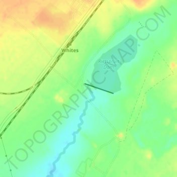
Name: Rietspruit Dam topographic map, elevation, terrain.
Average elevation: 1,364 m
Minimum elevation: 1,348 m
Maximum elevation: 1,380 m
Thank you for supporting this site ❤️
Make a donation
Make a donation
Other topographic maps
Click on a map to view its topography, its elevation and its terrain.
Bronville
South Africa > Free State > Lejweleputswa District Municipality > Matjhabeng Local Municipality
Average elevation: 1,365 m
Highveld
South Africa > Free State > Lejweleputswa District Municipality > Matjhabeng Local Municipality
Average elevation: 1,380 m
Huis Ougoud Retirement Village
South Africa > Free State > Lejweleputswa District Municipality > Matjhabeng Local Municipality
Average elevation: 1,349 m
Riebeeckstad
South Africa > Free State > Lejweleputswa District Municipality > Matjhabeng Local Municipality
Average elevation: 1,384 m
Thank you for supporting this site ❤️
Make a donation
Make a donation