
Thank you for supporting this site ❤️
Make a donation
Make a donation
Heimbach topographic map
Click on the map to display elevation.
Thank you for supporting this site ❤️
Make a donation
Make a donation
About this map
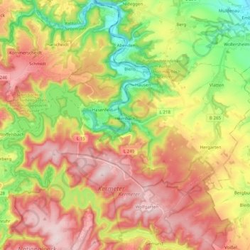
Name: Heimbach topographic map, elevation, terrain.
Location: Heimbach, Kreis Düren, Noordrijn-Westfalen, 52396, Duitsland (50.59737 6.38142 50.66421 6.57757)
Average elevation: 356 m
Minimum elevation: 174 m
Maximum elevation: 536 m
Thank you for supporting this site ❤️
Make a donation
Make a donation
Other topographic maps
Click on a map to view its topography, its elevation and its terrain.
Thank you for supporting this site ❤️
Make a donation
Make a donation
Am Wildenberg bei Hetzingen
Duitsland > Noordrijn-Westfalen > Kreis Düren > Nideggen
Average elevation: 254 m
Thank you for supporting this site ❤️
Make a donation
Make a donation
Thank you for supporting this site ❤️
Make a donation
Make a donation