
Thank you for supporting this site ❤️
Make a donation
Make a donation
Hamich topographic map
Click on the map to display elevation.
Thank you for supporting this site ❤️
Make a donation
Make a donation
About this map
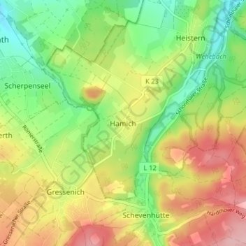
Name: Hamich topographic map, elevation, terrain.
Average elevation: 213 m
Minimum elevation: 146 m
Maximum elevation: 294 m
Thank you for supporting this site ❤️
Make a donation
Make a donation
Other topographic maps
Click on a map to view its topography, its elevation and its terrain.
Thank you for supporting this site ❤️
Make a donation
Make a donation
Am Wildenberg bei Hetzingen
Duitsland > Noordrijn-Westfalen > Kreis Düren > Nideggen
Average elevation: 254 m
Thank you for supporting this site ❤️
Make a donation
Make a donation
Naturschutzgebiet Rurtal
Duitsland > Noordrijn-Westfalen > Kreis Düren > Rath
Average elevation: 260 m
Thank you for supporting this site ❤️
Make a donation
Make a donation