
Make a donation
Pietermaritzburg topographic map
Click on the map to display elevation.
Make a donation
About this map
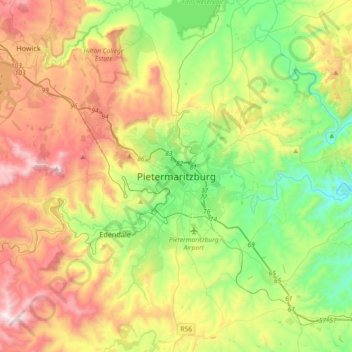
Name: Pietermaritzburg topographic map, elevation, terrain.
Average elevation: 853 m
Minimum elevation: 432 m
Maximum elevation: 1,510 m
Make a donation
Other topographic maps
Click on a map to view its topography, its elevation and its terrain.
Henley Dam
South Africa > KwaZulu-Natal > uMgungundlovu District Municipality > Msunduzi Local Municipality
Average elevation: 976 m
uMngeni River
South Africa > KwaZulu-Natal > uMgungundlovu District Municipality > uMgeni Local Municipality > Howick
Average elevation: 1,036 m
uKhahlamba / Drakensberg Park
South Africa > KwaZulu-Natal > uMgungundlovu District Municipality
The uKhahlamba-Drakensberg Park is a protected area in the KwaZulu-Natal province of South Africa, covering 2,428.13 km2 (938 sq mi), and is part of the Maloti-Drakensberg Park, a UNESCO World Heritage Site. The park includes Royal Natal National Park, a Provincial park, and covers part of the Drakensberg, an…
Average elevation: 1,762 m
Make a donation
uMngeni
South Africa > KwaZulu-Natal > uMgungundlovu District Municipality > uMgeni Local Municipality
Average elevation: 1,467 m
Mwgahumbe
South Africa > KwaZulu-Natal > uMgungundlovu District Municipality > Mkhambathini Local Municipality
Average elevation: 572 m
Richmond Local Municipality
South Africa > KwaZulu-Natal > uMgungundlovu District Municipality
Average elevation: 837 m
uMshwathi Local Municipality
South Africa > KwaZulu-Natal > uMgungundlovu District Municipality
Average elevation: 831 m
Make a donation
Mpofana
South Africa > KwaZulu-Natal > uMgungundlovu District Municipality > uMgeni Local Municipality
Average elevation: 1,332 m
eChibini Tarn
South Africa > KwaZulu-Natal > uMgungundlovu District Municipality > Impendle Local Municipality
Average elevation: 2,294 m
uMgeni Local Municipality
South Africa > KwaZulu-Natal > uMgungundlovu District Municipality
Average elevation: 1,334 m
Impendle Local Municipality
South Africa > KwaZulu-Natal > uMgungundlovu District Municipality
Average elevation: 1,725 m
Make a donation
Mkhambathini Local Municipality
South Africa > KwaZulu-Natal > uMgungundlovu District Municipality
Average elevation: 626 m
uKhahlamba / Drakensberg Park
South Africa > KwaZulu-Natal > uMgungundlovu District Municipality
The uKhahlamba-Drakensberg Park is a protected area in the KwaZulu-Natal province of South Africa, covering 2,428.13 km2 (938 sq mi), and is part of the Maloti-Drakensberg Park, a UNESCO World Heritage Site. The park includes Royal Natal National Park, a Provincial park, and covers part of the Drakensberg, an…
Average elevation: 1,762 m
Slangspruit
South Africa > KwaZulu-Natal > uMgungundlovu District Municipality > Pietermaritzburg
Average elevation: 705 m
Mkhambathini Local Municipality
South Africa > KwaZulu-Natal > uMgungundlovu District Municipality
Average elevation: 626 m
Make a donation
Mkhambathini Local Municipality
South Africa > KwaZulu-Natal > uMgungundlovu District Municipality
Average elevation: 626 m
Mkhambathini Local Municipality
South Africa > KwaZulu-Natal > uMgungundlovu District Municipality
Average elevation: 626 m
Mpofana Local Municipality
South Africa > KwaZulu-Natal > uMgungundlovu District Municipality
Average elevation: 1,240 m
Roman Baths
South Africa > KwaZulu-Natal > uMgungundlovu District Municipality > Mpofana Local Municipality
Average elevation: 1,930 m
Make a donation
uMshwathi Local Municipality
South Africa > KwaZulu-Natal > uMgungundlovu District Municipality
Average elevation: 831 m
Mkhambathini Local Municipality
South Africa > KwaZulu-Natal > uMgungundlovu District Municipality
Average elevation: 626 m
uMshwathi Local Municipality
South Africa > KwaZulu-Natal > uMgungundlovu District Municipality
Average elevation: 831 m
uMngeni River
South Africa > KwaZulu-Natal > uMgungundlovu District Municipality > uMgeni Local Municipality > Howick
Average elevation: 1,041 m
Make a donation
Impendle Local Municipality
South Africa > KwaZulu-Natal > uMgungundlovu District Municipality
Average elevation: 1,725 m
Camps Drift
South Africa > KwaZulu-Natal > uMgungundlovu District Municipality > Pietermaritzburg
Average elevation: 650 m
uMngeni
South Africa > KwaZulu-Natal > uMgungundlovu District Municipality > uMgeni Local Municipality
Average elevation: 1,083 m
Lions River
South Africa > KwaZulu-Natal > uMgungundlovu District Municipality > uMgeni Local Municipality
Average elevation: 1,161 m
Make a donation