
Thank you for supporting this site ❤️
Make a donation
Make a donation
Mimasaka topographic map
Click on the map to display elevation.
Thank you for supporting this site ❤️
Make a donation
Make a donation
About this map
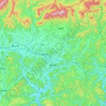
Name: Mimasaka topographic map, elevation, terrain.
Location: Mimasaka, Okayama Prefecture, Japan (34.88089 134.08613 35.21098 134.41316)
Average elevation: 298 m
Minimum elevation: 34 m
Maximum elevation: 1,230 m
Thank you for supporting this site ❤️
Make a donation
Make a donation
Other topographic maps
Click on a map to view its topography, its elevation and its terrain.