
Thank you for supporting this site ❤️
Make a donation
Make a donation
Barntrup topographic map
Click on the map to display elevation.
Thank you for supporting this site ❤️
Make a donation
Make a donation
About this map
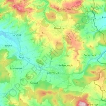
Name: Barntrup topographic map, elevation, terrain.
Location: Barntrup, Kreis Lippe, Noordrijn-Westfalen, 32683, Duitsland (51.96794 9.03764 52.05027 9.19732)
Average elevation: 236 m
Minimum elevation: 135 m
Maximum elevation: 432 m
Thank you for supporting this site ❤️
Make a donation
Make a donation
Other topographic maps
Click on a map to view its topography, its elevation and its terrain.