
Thank you for supporting this site ❤️
Make a donation
Make a donation
Herolds Bay topographic map
Click on the map to display elevation.
Thank you for supporting this site ❤️
Make a donation
Make a donation
About this map
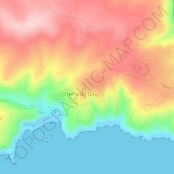
Name: Herolds Bay topographic map, elevation, terrain.
Average elevation: 105 m
Minimum elevation: -1 m
Maximum elevation: 217 m
Thank you for supporting this site ❤️
Make a donation
Make a donation
Other topographic maps
Click on a map to view its topography, its elevation and its terrain.
Tsitsikamma National Park (Marine Reserve)
South Africa > Western Cape > George
Average elevation: 50 m
Thank you for supporting this site ❤️
Make a donation
Make a donation