
Make a donation
Kampemba I topographic map
Click on the map to display elevation.
Make a donation
About this map
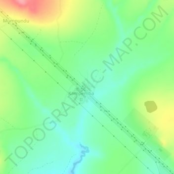
Name: Kampemba I topographic map, elevation, terrain.
Location: Kampemba I, Haut-Katanga, Democratic Republic of the Congo (-10.96280 26.61945 -10.92280 26.65945)
Average elevation: 1,290 m
Minimum elevation: 1,254 m
Maximum elevation: 1,356 m
Make a donation
Other topographic maps
Click on a map to view its topography, its elevation and its terrain.
Kamina
Democratic Republic of the Congo > Haut-Katanga > Ville de Lubumbashi > N'sele
Average elevation: 1,207 m
Bel-Air 1
Democratic Republic of the Congo > Haut-Katanga > Ville de Lubumbashi
Average elevation: 1,258 m
Mohamed
Democratic Republic of the Congo > Haut-Katanga > Ville de Lubumbashi > Lubumbashi
Average elevation: 1,288 m
Make a donation
Météo
Democratic Republic of the Congo > Haut-Katanga > Ville de Lubumbashi > Météo
Average elevation: 1,251 m