
Thank you for supporting this site ❤️
Make a donation
Make a donation
Likasi topographic map
Click on the map to display elevation.
Thank you for supporting this site ❤️
Make a donation
Make a donation
About this map
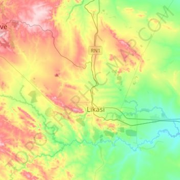
Name: Likasi topographic map, elevation, terrain.
Location: Likasi, Haut-Katanga, Democratic Republic of the Congo (-11.04605 26.63073 -10.87974 26.88009)
Average elevation: 1,273 m
Minimum elevation: 1,143 m
Maximum elevation: 1,472 m
Thank you for supporting this site ❤️
Make a donation
Make a donation
Other topographic maps
Click on a map to view its topography, its elevation and its terrain.