
Area G (Forster Creek/Mount Assiniboine) topographic map
Interactive map
Click on the map to display elevation.
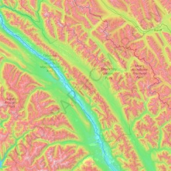
Area G (Forster Creek/Mount Assiniboine) topographic map, elevation, terrain
About this map
Name: Area G (Forster Creek/Mount Assiniboine) topographic map, elevation, terrain.
Average elevation: 1,808 m
Minimum elevation: 782 m
Maximum elevation: 3,531 m
Other topographic maps
Click on a map to view its topography, its elevation and its terrain.
Elk River
Canada > British Columbia > Regional District of East Kootenay > Fernie
Average elevation: 1,134 m