
Thank you for supporting this site ❤️
Make a donation
Make a donation
Ogden topographic map
Click on the map to display elevation.
Thank you for supporting this site ❤️
Make a donation
Make a donation
About this map
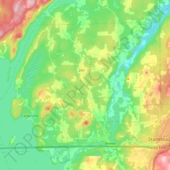
Name: Ogden topographic map, elevation, terrain.
Location: Ogden, Memphrémagog, Estrie, Quebec, Canada (45.00473 -72.25190 45.08647 -72.09593)
Average elevation: 253 m
Minimum elevation: 167 m
Maximum elevation: 424 m
Thank you for supporting this site ❤️
Make a donation
Make a donation
Other topographic maps
Click on a map to view its topography, its elevation and its terrain.
Scouts Canada - Lake Lovering Scouts Reserve
Canada > Quebec > Memphrémagog > Magog
Average elevation: 260 m
Thank you for supporting this site ❤️
Make a donation
Make a donation
Thank you for supporting this site ❤️
Make a donation
Make a donation