
Make a donation
Niagara Escarpment topographic map
Click on the map to display elevation.
Make a donation
About this map
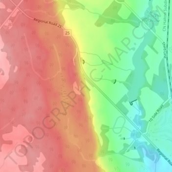
Name: Niagara Escarpment topographic map, elevation, terrain.
Average elevation: 299 m
Minimum elevation: 231 m
Maximum elevation: 350 m
Make a donation
Other topographic maps
Click on a map to view its topography, its elevation and its terrain.
Ottawa
Ottawa, the capital city of Canada, is situated on the south bank of the Ottawa River at the confluence with the Rideau River. The city's topography is characterized by gently rolling terrain with elevations ranging from approximately 44 meters (144 feet) above sea level at the Ottawa River to its highest…
Average elevation: 105 m
Toronto
Despite its deep ravines, Toronto is not remarkably hilly, but its elevation does increase steadily away from the lake. Elevation differences range from 76.5 metres (251 ft) above sea level at the Lake Ontario shore to 209 m (686 ft) ASL near the York University grounds in the city's north end at the…
Average elevation: 139 m
Make a donation
Kitchener
Canada > Ontario > Region of Waterloo
Kitchener is located in Southwestern Ontario, in the Saint Lawrence Lowlands. This geological and climatic region has wet-climate soils and deciduous forests. Situated in the Grand River Valley, the area is generally above 300 m (1,000 ft) in elevation.
Average elevation: 336 m
Toronto
Despite its deep ravines, Toronto is not remarkably hilly, but its elevation does increase steadily away from the lake. Elevation differences range from 76.5 metres (251 ft) above sea level at the Lake Ontario shore to 209 m (686 ft) above sea level near the York University grounds in the city's north end at…
Average elevation: 139 m
Make a donation
Markham
Canada > Ontario > York Region
Markham's average altitude is at 200 m (660 ft) and in general consists of gently rolling hills. The city is intersected by two rivers; the Don River and Rouge River, as well as their tributaries. To the north is the Oak Ridges Moraine, which further elevates the elevation towards the north.
Average elevation: 216 m
Make a donation
Hamilton
The airport's open, rural location and higher altitude results in lower temperatures, generally windier conditions, and higher snowfall amounts than lower, built-up areas of the city. The highest temperature ever recorded in Hamilton was 41.1 °C (106 °F) on July 14, 1868. The coldest temperature ever…
Average elevation: 187 m
Make a donation
Richmond Hill
Canada > Ontario > York Region
The village of Richmond Hill was incorporated by a bylaw of the York County Council on June 18, 1872, coming into effect January 1, 1873. In September 1956, the Ontario Municipal Board approved its elevation to Town status, effective January 1, 1957.
Average elevation: 256 m
Lion's Head Provincial Nature Reserve
Canada > Ontario > Bruce County > Lion's Head
Average elevation: 206 m
Mississauga
Canada > Ontario > Peel Region
The shoreline of former Glacial Lake Iroquois roughly follows the Dundas Street alignment, although it is not noticeable in some places but is more prominent in others, such as the site of the former brickyard (Shoreline Dr. near Mavis Rd.), the ancient shoreline promenteau affords a clear view of downtown…
Average elevation: 151 m
Make a donation
Barrie
On September 7, 1977, a private aircraft, flown by "Army" Hollingsworth, dropped altitude to 500 feet (152 m) in dense fog and struck CKVR's 1,000-foot (305 m) transmitter tower, killing all five people aboard the plane and destroying the tower and antenna. The station's 225-foot (69 m) auxiliary tower was…
Average elevation: 265 m
Make a donation
Dogtooth Lake
Canada > Ontario > Kenora District > Unorganized Kenora District
Average elevation: 361 m
Make a donation
North Bay
Canada > Ontario > Nipissing District
The climate in North Bay is common to most places in Northern Ontario. North Bay tends to be a less humid climate than that found in Southern Ontario due somewhat to the distance from the Great Lakes and less warm than some other locations in Northern Ontario due to cooling from Lake Nipissing. On May 31,…
Average elevation: 266 m
Make a donation
Make a donation
Make a donation
Scarborough
Topographically, Scarborough is dominated by two watersheds, Highland Creek and the Rouge River. Highland Creek lies almost entirely within Scarborough and occupies approximately 70% of its total area. It occupies the western half of Scarborough, while the Rouge River flows through the eastern portion. Both of…
Average elevation: 138 m
Simcoe County
The road network in Simcoe County is based on a grid pattern, with most roads running north–south or east–west. The topography of the land has permitted roads to be set in predominantly straight lines.
Average elevation: 265 m
Make a donation
Make a donation
Make a donation
Newmarket
Canada > Ontario > York Region
Newmarket's geographical coordinates are 44.05°N, 79.46°W, and its elevation above sea level is 252 m. It has an area of 38.33 km². The town is bounded on the south by Aurora, on the west by King, on the north by East Gwillimbury and on the east by Whitchurch–Stouffville.
Average elevation: 270 m
St. Catharines
Canada > Ontario > Niagara Region
The most defining transportation icon of St. Catharines is the Welland Canal, a ship canal that runs 43.4 kilometres (27.0 mi), passing through the city. Four of its locks are within city boundaries. The canal allows shipping vessels to traverse the 99.5-metre (326.5 ft) drop in altitude from Lake Erie to Lake…
Average elevation: 103 m
Make a donation
Lake Nipissing
Canada > Ontario > Nipissing District
Lake Nipissing (/ˈnɪpəsɪŋ/; French: lac Nipissing, Ojibwe: Gichi-nibiinsing-zaaga’igan) is a lake in the Canadian province of Ontario. It has a surface area of 873.3 km2 (337.2 sq mi), a mean elevation of 196 m (643 ft) above sea level, and is located between the Ottawa River and Georgian Bay. Lake…
Average elevation: 272 m
Make a donation
Lake Ontario
Lake Ontario is the easternmost of the Great Lakes and the smallest in surface area (7,340 sq mi, 18,960 km2), although it exceeds Lake Erie in volume (393 cu mi, 1,639 km3). It is the 13th largest lake in the world. When its islands are included, the lake's shoreline is 712 miles (1,146 km) long. As the last…
Average elevation: 214 m
Eastern Ontario
Along the extreme western edge of Eastern Ontario is a continuation of the Laurentian Highlands, known as the Opeongo Hills, and they contain some of the highest elevations in Southern Ontario. They stretch into the northern portions of Central Ontario, near Algonquin Provincial Park.
Average elevation: 243 m
Make a donation
Make a donation
Sarnia
Canada > Ontario > Lambton County
Sarnia is located on the eastern shore of Lake Huron at its extreme southern point, where it flows into the St. Clair River. Most of the surrounding area is flat, and the elevation ranges from 169 metres (554 ft) and 281 metres (922 ft) above sea level. The soil mostly comprises clay. Despite this high…
Average elevation: 186 m
Make a donation
Kapuskasing
Canada > Ontario > Cochrane District
Kapuskasing lies in the heart of the Great Clay Belt. The topography of the region is very flat, dotted with numerous small lakes and muskeg bogs. Also in the heart of Canada's boreal forest, the region is drained by rivers running north to James Bay. The district is heavily forested, mostly by thick stands of…
Average elevation: 227 m
Kawartha Highlands Provincial Park
Canada > Ontario > Peterborough County > North Kawartha
Average elevation: 306 m
Make a donation
Make a donation
St. Joseph Island
Canada > Ontario > Algoma District > Jocelyn Township
Its highest point, known colloquially and by surveyors as "the Mountain", is near the centre of the island near Carterton with an elevation of 345.6 m, which is about 169 m above Lake Huron.
Average elevation: 196 m
Guelph
This region of Ontario has cold winters and warm, humid summers, falling into the Köppen climate classification Dfb zone (humid continental), with moderately high rainfall and snowfall. It is generally a couple of degrees cooler than lower elevation regions on the Great Lakes shorelines, especially so in…
Average elevation: 335 m
Niagara River
Canada > Ontario > Niagara Region > Niagara Falls
The river, occasionally described as a strait, is approximately 58 kilometres (36 mi) long and includes Niagara Falls. Over the past 12,000 years, the falls have moved roughly 11 kilometres (6.8 mi) upstream from the leading edge of the Niagara Escarpment, creating a gorge below the falls. Today, the diversion…
Average elevation: 177 m
Make a donation
Trent Lakes
Canada > Ontario > Peterborough County
The lumber and agricultural industries are significant to the history of the township. Due to the topography of the region, agricultural production was limited to only certain areas where soil conditions were adequate and cattle and mixed farming (orchards, cattle, horses, sheep, grains, vegetables, chickens…
Average elevation: 293 m
London
London has a humid continental climate (Köppen Dfb), though due to its downwind location relative to Lake Huron and elevation changes across the city, it is virtually on the Dfa/Dfb (hot summer) boundary favouring the former climate zone to the southwest of the confluence of the South and North Thames Rivers,…
Average elevation: 263 m
Caliper Lake Provincial Park
Canada > Ontario > Kenora District > Sioux Narrows-Nestor Falls Township
Average elevation: 338 m
Make a donation
Carroll Lake
Canada > Ontario > Kenora District > Unorganized Kenora District
Average elevation: 338 m
Make a donation
South-West Oxford
Canada > Ontario > Oxford County > South-West Oxford
In its wilderness state, the former Dereham township had thousands of acres of swamp and marsh land which limited its use for agriculture. Several large drainage projects brought great improvement and remain as essential parts of the township's farmland infrastructure. The township topography still has several…
Average elevation: 281 m
Make a donation
Trent-Severn Waterway
Canada > Ontario > Peterborough County > North Kawartha > Burleigh Falls
Average elevation: 249 m
Make a donation