
Make a donation
Caraga topographic map
Click on the map to display elevation.
Make a donation
Caraga
Father Saturnino Urios University, was founded by Caraga's most loved Spanish missionary, Fr. Saturnino Urios S.J. in 1990. The Commission on Higher Education (CHED) recognized Father Saturnino Urios University as one of the best schools in the region producing top notchers in national board examinations in Nursing, Engineering, and Accountancy. Its performance in the Licensure Examinations for Teachers (LET) and the Philippine Bar (BAR) is also relatively high. On July 12, 2006, Urios College formally announced its elevation into a university and is now renamed Fr. Saturnino Urios University (FSUU), the first home-grown university in Caraga.
Make a donation
About this map
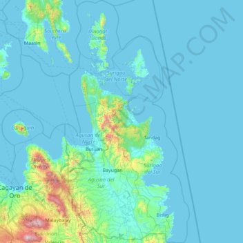
Name: Caraga topographic map, elevation, terrain.
Location: Caraga, Philippines (7.89663 125.20680 10.60837 126.61893)
Average elevation: 136 m
Minimum elevation: 0 m
Maximum elevation: 2,783 m
Make a donation
Other topographic maps
Click on a map to view its topography, its elevation and its terrain.
Antipolo
Its higher elevation than that of Metro Manila affords it a scenic view of the metropolis, especially at night. Its locally grown mangoes and cashews are popular among tourists, as well as suman – a local delicacy made out of glutinous rice. The Hinulugang Taktak National Park, which was once a popular…
Average elevation: 125 m
Make a donation
Make a donation
Make a donation
Make a donation
Make a donation
Muntinlupa
There are three plausible origins of the name of the city: First, is its association with the thin topsoil in the area; second, residents, purportedly replying to a question by Spaniards in the 16th century what the name of their place was, said “Monte sa Lupa”—apparently mistaking the question for what…
Average elevation: 41 m
Make a donation
Make a donation