
Smallwood Reservoir topographic map
Interactive map
Click on the map to display elevation.
About this map
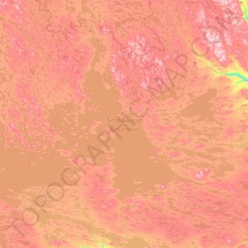
Name: Smallwood Reservoir topographic map, elevation, terrain.
Location: Smallwood Reservoir, Neufundland und Labrador, Kanada (53.75208 -65.61435 54.70985 -63.34200)
Average elevation: 490 m
Minimum elevation: 260 m
Maximum elevation: 734 m
Other topographic maps
Click on a map to view its topography, its elevation and its terrain.
Gander
Kanada > Neufundland und Labrador > Gander
Gander, Newfoundland, Neufundland und Labrador, Kanada
Average elevation: 100 m
Lake Melville
Kanada > Neufundland und Labrador
Lake Melville, Nunatsiavut, Neufundland und Labrador, Kanada
Average elevation: 0 m
St. John's
Kanada > Neufundland und Labrador > St. John's
St. John's, Newfoundland, Neufundland und Labrador, A1C 2G4, Kanada
Average elevation: 66 m
Churchill Falls
Kanada > Neufundland und Labrador > Churchill Falls
Churchill Falls, Labrador, Neufundland und Labrador, Kanada
Average elevation: 341 m