
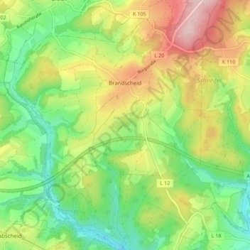
Brandscheid topographic map
Interactive map
Click on the map to display elevation.
About this map
Name: Brandscheid topographic map, elevation, terrain.
Average elevation: 488 m
Minimum elevation: 387 m
Maximum elevation: 634 m
Brandscheid liegt am südwestlichen Ende des Schneifel-Höhenrückens im Naturpark Nordeifel.
Other topographic maps
Click on a map to view its topography, its elevation and its terrain.
Oberweis
Deutschland > Rheinland-Pfalz > Eifelkreis Bitburg-Prüm
Oberweis, Bitburger Land, Eifelkreis Bitburg-Prüm, Rheinland-Pfalz, Deutschland
Average elevation: 302 m
Olsdorf
Deutschland > Rheinland-Pfalz > Eifelkreis Bitburg-Prüm
Olsdorf, Bitburger Land, Eifelkreis Bitburg-Prüm, Rheinland-Pfalz, Deutschland
Average elevation: 348 m
Neuendorf
Deutschland > Rheinland-Pfalz > Eifelkreis Bitburg-Prüm > Neuendorf
Neuendorf, Prüm, Eifelkreis Bitburg-Prüm, Rheinland-Pfalz, Deutschland
Average elevation: 583 m
Speicher
Deutschland > Rheinland-Pfalz > Eifelkreis Bitburg-Prüm
Speicher, Eifelkreis Bitburg-Prüm, Rheinland-Pfalz, 54662, Deutschland
Average elevation: 305 m