
Oberweis topographic map
Interactive map
Click on the map to display elevation.
About this map
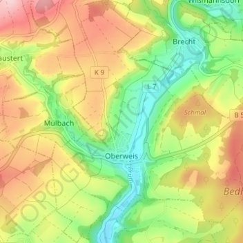
Name: Oberweis topographic map, elevation, terrain.
Average elevation: 302 m
Minimum elevation: 213 m
Maximum elevation: 402 m
Der Ort liegt in der Südwesteifel, etwa 10 km westlich der Kreisstadt Bitburg an der Prüm, sowohl an der Verbindung Trier–Bitburg, als auch Neuerburg–Vianden. Der Höhenmesspunkt für Oberweis liegt bei 240 m ü. NHN, 302 ha des Gemeindegebietes sind bewaldet.
Other topographic maps
Click on a map to view its topography, its elevation and its terrain.
Brandscheid
Deutschland > Rheinland-Pfalz > Eifelkreis Bitburg-Prüm
Brandscheid, Prüm, Eifelkreis Bitburg-Prüm, Rheinland-Pfalz, Deutschland
Average elevation: 488 m
Olsdorf
Deutschland > Rheinland-Pfalz > Eifelkreis Bitburg-Prüm
Olsdorf, Bitburger Land, Eifelkreis Bitburg-Prüm, Rheinland-Pfalz, Deutschland
Average elevation: 348 m
Neuendorf
Deutschland > Rheinland-Pfalz > Eifelkreis Bitburg-Prüm > Neuendorf
Neuendorf, Prüm, Eifelkreis Bitburg-Prüm, Rheinland-Pfalz, Deutschland
Average elevation: 583 m
Speicher
Deutschland > Rheinland-Pfalz > Eifelkreis Bitburg-Prüm
Speicher, Eifelkreis Bitburg-Prüm, Rheinland-Pfalz, 54662, Deutschland
Average elevation: 305 m