
Weiswampach topographic map
Interactive map
Click on the map to display elevation.
About this map
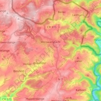
Name: Weiswampach topographic map, elevation, terrain.
Location: Weiswampach, Canton Clervaux, Luxembourg (50.09429 6.00552 50.17199 6.12561)
Average elevation: 475 m
Minimum elevation: 304 m
Maximum elevation: 561 m
Other topographic maps
Click on a map to view its topography, its elevation and its terrain.
Reuler
Luxembourg > Canton Clervaux > Clervaux
Reuler, Clervaux, Canton Clervaux, 9768, Luxembourg
Average elevation: 456 m
Lieler
Luxembourg > Canton Clervaux > Clervaux > Lieler
Lieler, Clervaux, Canton Clervaux, 9972, Luxembourg
Average elevation: 448 m
Hosingen
Luxembourg > Canton Clervaux > Parc Hosingen
Hosingen, Parc Hosingen, Canton Clervaux, 9806, Luxembourg
Average elevation: 464 m
Parc Hosingen
Parc Hosingen, Canton Clervaux, Luxembourg
Average elevation: 417 m