
Make a donation
Fujian topographic map
Click on the map to display elevation.
Make a donation
Fujian
The province is mostly mountainous and is traditionally said to be "eight parts mountain, one part water, and one part farmland" (八山一水一分田). The northwest is higher in altitude, with the Wuyi Mountains forming the border between Fujian and Jiangxi. It is the most forested provincial-level administrative region in China, with a 62.96% forest coverage rate in 2009. Fujian's highest point is Mount Huanggang in the Wuyi Mountains, with an altitude of 2,157 metres (1.340 mi).
Make a donation
About this map
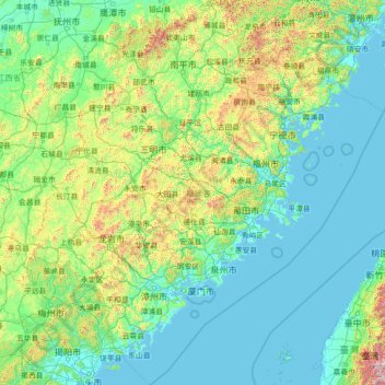
Name: Fujian topographic map, elevation, terrain.
Location: Fujian, China (23.19948 115.84731 28.32052 121.03366)
Average elevation: 302 m
Minimum elevation: -2 m
Maximum elevation: 3,588 m
Make a donation
Other topographic maps
Click on a map to view its topography, its elevation and its terrain.
Jade Dragon Snow Mountain
China > Yunnan > Lijiang City
The view of the massif from the gardens at the Black Dragon Pool (Heilong Tan) in Lijiang is noted as one of China's finest views. The mountain is part of Yulong Snow Mountain National Scenic Area and National Geological Park, an AAAAA-classified scenic area. The Park operates a tourist cable car that climbs…
Average elevation: 4,829 m
Shanghai
The golden age of Shanghai began with its elevation to municipality after it was separated from Jiangsu on 7 July 1927. This new Chinese municipality covered an area of 494.69 km2 (191.0 sq mi), including the modern-day districts of Baoshan, Yangpu, Zhabei, Nanshi, and Pudong, but excluded the foreign…
Average elevation: 5 m
Make a donation
Make a donation
Make a donation