
Thank you for supporting this site ❤️
Make a donation
Make a donation
Upper Austria topographic map
Click on the map to display elevation.
Thank you for supporting this site ❤️
Make a donation
Make a donation
About this map
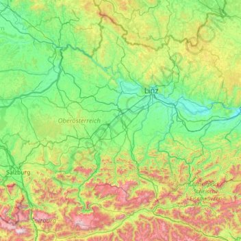
Name: Upper Austria topographic map, elevation, terrain.
Location: Upper Austria, Austria (47.46111 12.74924 48.77256 14.99217)
Average elevation: 722 m
Minimum elevation: 217 m
Maximum elevation: 2,877 m
Thank you for supporting this site ❤️
Make a donation
Make a donation
Other topographic maps
Click on a map to view its topography, its elevation and its terrain.
Förolach
Austria > Carinthia > Bezirk Hermagor > Hermagor-Pressegger See > Görtschach
Average elevation: 797 m
Steinerne Mühl
Austria > Upper Austria > Bezirk Rohrbach > Sankt Peter am Wimberg
Average elevation: 599 m
Thank you for supporting this site ❤️
Make a donation
Make a donation