
Make a donation
Philadelphia topographic map
Click on the map to display elevation.
Make a donation
About this map
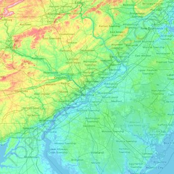
Name: Philadelphia topographic map, elevation, terrain.
Location: Philadelphia, Pennsylvania, 19140, United States (39.31145 -75.83265 40.71145 -74.43265)
Average elevation: 68 m
Minimum elevation: -4 m
Maximum elevation: 496 m
Make a donation
Other topographic maps
Click on a map to view its topography, its elevation and its terrain.
Pittsburgh
United States > Pennsylvania > Allegheny County
Pittsburgh, located in Allegheny County, Pennsylvania, is characterized by its distinct and varied topography, shaped by the confluence of the Allegheny, Monongahela, and Ohio rivers. The city itself is situated at an average elevation of approximately 764 feet (233 meters) above sea level, with the terrain…
Average elevation: 303 m
Philadelphia
United States > Pennsylvania > Philadelphia County
Philadelphia, located at the confluence of the Delaware and Schuylkill Rivers, features a diverse topography characterized by its gentle slopes and valleys. The city lies on the Atlantic Seaboard Fall Line, transitioning from the flat Coastal Plain to the more rugged Piedmont region. This unique geographical…
Average elevation: 44 m
Make a donation
Centre County
Centre County has a humid continental climate (Dfb/Dfa at lower elevations).
Average elevation: 427 m
Make a donation
State College
United States > Pennsylvania > Centre County
State College is situated at an elevation of approximately 1,200 feet (370 m) above sea level. According to the U.S. Census Bureau, the borough has a total area of 4.5 square miles (12 km2), all of it land. It is surrounded by large tracts of farmland, and an expanse of Appalachian Mountain ranges and forests.…
Average elevation: 351 m
Bucks County
According to the Trewartha climate classification system, the Piedmont (United States) section of Bucks County, which is located roughly northwest of U.S. Route 1, has a Temperate Continental Climate with hot and slightly humid summers, cold winters and year-around precipitation (Dcao). Dcao climates are…
Average elevation: 98 m
Wayne County
The highest elevation in the county, 2,659 ft (810 m), is the summit of Mount Ararat in Orson. Two other summits at the north end of the same ridge also exceed 2,640 ft (800 m) in elevation. The county's lowest point, at approximately 680 ft (210 m) above sea level, is along the Delaware, near Wayne County's…
Average elevation: 436 m
Make a donation
Chester County
Chester County lies within southeastern Pennsylvania’s Piedmont landscape, where the terrain is shaped by a sequence of rolling uplands, elongated ridges, and stream-cut valleys rather than by broad plains or high mountains. Its relief is especially varied across the northern and western parts of the county,…
Average elevation: 124 m
Make a donation
Make a donation
Make a donation
McConnellsburg
United States > Pennsylvania > Fulton County
According to the United States Census Bureau, the borough has a total area of 0.35 square miles (0.9 km2), all land. The elevation in the center of town is 896 feet (273 m) above sea level.
Average elevation: 290 m
Make a donation
Bridgeville
United States > Pennsylvania > Allegheny County
Even more significant to the development of Bridgeville was the advent of commercial coal mining. The Pittsburgh Coal Seam was perhaps the most valuable mineral resource in North America in the late 1800s. Ranging from forty inches to six feet thick it was located at an elevation that produced outcroppings on…
Average elevation: 275 m
Make a donation
Somerset County
Somerset County along with Garrett County is one of the snowiest inhabited locations in the United States, with the highest elevations of the county averaging 150+ inches of snow each winter. The county's elevation and general proximity to both the Great Lakes and the Atlantic Ocean causes snow from both…
Average elevation: 632 m
Make a donation
Luzerne County
The Wyoming Valley, also referred to as the Anthracite Valley Section of Pennsylvania, runs directly through Luzerne County. It extends from the northeastern border (with Lackawanna County) to the western border (with Columbia County). The valley is flat (at the Susquehanna Basin) and rises from 512 feet (156…
Average elevation: 402 m
Make a donation
Carlisle
United States > Pennsylvania > Cumberland County
Carlisle is located slightly northeast of the center of Cumberland County at 40°12′9″N 77°11′42″W / 40.20250°N 77.19500°W / 40.20250; -77.19500 (40.202553, −77.195016) at an elevation of 479 feet (146 m).[24][25] The borough lies in the Cumberland Valley, a section of the Great…
Average elevation: 148 m
Make a donation
Allegheny County
Allegheny has a humid continental climate which is hot-summer, (Dfa) except in higher elevations, where it is warm-summer (Dfb).
Average elevation: 325 m
Make a donation
Lehigh County
Lehigh County borders two Appalachian mountain ridges. To the north, the county borders Blue Mountain, which has an altitude of 1,300 to 1,604 feet (396 to 489 m). To the south, it is bordered by South Mountain, which has an altitude of 700 to 1,100 feet (210 to 340 m) and cuts through the southern portions of…
Average elevation: 186 m
Make a donation
Make a donation
Make a donation
Make a donation
Make a donation
Make a donation
Sullivan County
Elevation ranges from 2593 ft at North Mountain in Davidson Township to 779 ft on Loyalsock Creek at the Lycoming County line. The county is served by Pennsylvania Route 42, Pennsylvania Route 87, Pennsylvania Route 154, Pennsylvania Route 487, and U.S. Route 220. The major rivers in the county are Loyalsock…
Average elevation: 491 m
State College
United States > Pennsylvania > Centre County
State College is situated at an elevation of approximately 1,200 feet (370 m) above sea level. According to the U.S. Census Bureau, the borough has a total area of 4.5 square miles (12 km2), all of it land. It is surrounded by large tracts of farmland, and an expanse of Appalachian Mountain ranges and forests.…
Average elevation: 351 m
Make a donation
Pike County
The terrain rises rapidly from the river valley in the east to the rolling foothills of the Poconos in the west. The highest point is one of two unnamed hills in Greene Township that top out at approximately 2,110 feet (643 m) above sea level. The lowest elevation is approximately 340 feet (103.6 m), at the…
Average elevation: 361 m
Make a donation
Erie County
Most of the county has a warm-summer humid continental climate (Dfb), except at lower elevations near enough to the lake, where a hot-summer humid continental climate (Dfa) exists. Average monthly temperatures in downtown Erie range from 26.4 °F in January to 70.8 °F in July, while in Corry they range from…
Average elevation: 248 m
Stroudsburg
United States > Pennsylvania > Monroe County
Stroudsburg's elevation is 500 feet (150 m) above sea level.
Average elevation: 147 m
Make a donation
Monroe County
According to the Trewartha climate classification system, the higher elevation Pocono Plateau Region of Monroe County has a Temperate Continental climate (Dc) with warm summers (b), cold winters (o) and year-around precipitation (Dcbo). Dcbo climates are characterized by at least one month having an average…
Average elevation: 361 m
Make a donation
Export
United States > Pennsylvania > Westmoreland County
Export is characterized by a varied terrain that reflects its location in the Allegheny Plateau region. The borough sits at an average elevation of around 1,122 feet (342 meters) and features rolling hills and valleys typical of southwestern Pennsylvania's topography. The surrounding landscape is marked by…
Average elevation: 342 m
Make a donation
Montour County
Montour County is located in the Ridge-and-Valley Province of the Appalachian Mountains. A total of 65% of the soils in the county are well-drained. The Muncy Hills are located in the northern part of the county and Montour Ridge is located in the southern part of the county, not far from the Susquehanna…
Average elevation: 225 m
Make a donation
Make a donation