
Lewes topographic map
Interactive map
Click on the map to display elevation.
About this map
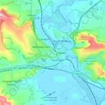
Name: Lewes topographic map, elevation, terrain.
Location: Lewes, East Sussex, England, United Kingdom (50.85948 -0.03090 50.88925 0.04931)
Average elevation: 40 m
Minimum elevation: -2 m
Maximum elevation: 192 m
Other topographic maps
Click on a map to view its topography, its elevation and its terrain.
Westham
United Kingdom > England > East Sussex > Wealden > Hankham
Westham, Hankham, Wealden, East Sussex, England, United Kingdom
Average elevation: 6 m
Rodmell
United Kingdom > England > East Sussex > Lewes > Rodmell
Rodmell, Lewes, East Sussex, England, United Kingdom
Average elevation: 47 m
Westdean
United Kingdom > England > East Sussex > Wealden
Westdean, Wealden, East Sussex, England, BN25 4AL, United Kingdom
Average elevation: 48 m
Newhaven
United Kingdom > England > East Sussex > Mount Pleasant
Newhaven, Mount Pleasant, Lewes, East Sussex, England, United Kingdom
Average elevation: 19 m
Brighton
United Kingdom > England > East Sussex
Brighton, East Sussex, England, BN1 1HH, United Kingdom
Average elevation: 28 m
Forest Row
United Kingdom > England > East Sussex > Wealden
Forest Row, Wealden, East Sussex, England, United Kingdom
Average elevation: 104 m
Glynde
United Kingdom > England > East Sussex > Lewes > Glynde
Glynde, Lewes, East Sussex, England, United Kingdom
Average elevation: 31 m
Wivelsfield Green
United Kingdom > England > East Sussex > Lewes
Wivelsfield Green, Lewes, East Sussex, England, RH17 7RP, United Kingdom
Average elevation: 45 m
Barcombe
United Kingdom > England > East Sussex > Lewes > Barcombe Cross
Barcombe, Barcombe Cross, Lewes, East Sussex, England, United Kingdom
Average elevation: 22 m
St Leonards
United Kingdom > England > East Sussex > St Leonards
St Leonards, Hastings, East Sussex, South East England, England, TN38 0NY, United Kingdom
Average elevation: 31 m