
Thank you for supporting this site ❤️
Make a donation
Make a donation
Austin topographic map
Click on the map to display elevation.
Thank you for supporting this site ❤️
Make a donation
Make a donation
About this map
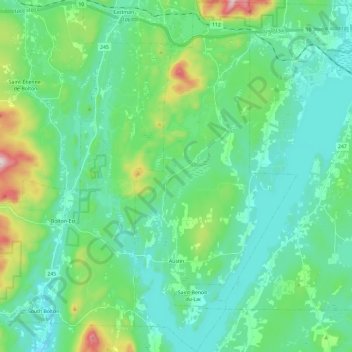
Name: Austin topographic map, elevation, terrain.
Location: Austin, Memphrémagog, Estrie, Quebec, J0B 1B0, Canada (45.14112 -72.30834 45.30669 -72.19943)
Average elevation: 290 m
Minimum elevation: 183 m
Maximum elevation: 697 m
Thank you for supporting this site ❤️
Make a donation
Make a donation
Other topographic maps
Click on a map to view its topography, its elevation and its terrain.
Scouts Canada - Lake Lovering Scouts Reserve
Canada > Quebec > Memphrémagog > Magog
Average elevation: 260 m
Thank you for supporting this site ❤️
Make a donation
Make a donation
Thank you for supporting this site ❤️
Make a donation
Make a donation