
Lassa topographic map
Interactive map
Click on the map to display elevation.
About this map
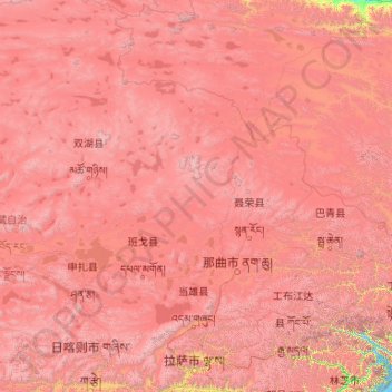
Name: Lassa topographic map, elevation, terrain.
Location: Lassa, Tibete, 850000, China (29.24065 89.75281 36.34330 95.16436)
Average elevation: 4,866 m
Minimum elevation: 2,877 m
Maximum elevation: 7,466 m
Com aproximadamente 200 mil habitantes, a cidade encontra-se a uma altitude de 3.490 metros acima do nível do mar, sendo uma das mais altas cidades do mundo. A cidade faz parte de um município-prefeitura, a Prefeitura de Lassa, que consiste em oito condados de pequeno porte: Lhünzhub, Damxung, Nyêmo, Qüxü, Doilungdêqên, Dagzê, Maizhokunggar e Distrito de Chengguan.
Other topographic maps
Click on a map to view its topography, its elevation and its terrain.
波密县 སྤོ་མེས་རྫོང།
波密县 སྤོ་མེས་རྫོང།, 林芝市 ཉིང་ཁྲི་གྲོང་ཁྱེར།, Tibete, 860000, China
Average elevation: 4,153 m
沙东乡
China > Tibete > 贡觉县 གོ་འཇོ་རྫོང།
沙东乡, 贡觉县 གོ་འཇོ་རྫོང།, 昌都市 ཆབ་མདོ་ས་ཁུལ།, Tibete, China
Average elevation: 3,879 m
那曲市 ནག་ཆུ།
那曲市 ནག་ཆུ།, 那曲镇, 色尼区 གསེར་རྙེད་ཆུས།, 那曲市 ནག་ཆུ་ས་ཁུལ།, Tibete, China
Average elevation: 4,624 m
城关区 ཁྲིན་ཀོན་ཆུས།
城关区 ཁྲིན་ཀོན་ཆུས།, Lassa, Tibete, 850000, China
Average elevation: 4,325 m
मकालु 马卡鲁山 Makalu
मकालु 马卡鲁山 Makalu, 定日县, 日喀则市, Tibete, China
Average elevation: 7,484 m
North Couloir
North Couloir, 扎西宗乡, དིང་རི་རྫོང་ / 定日县 / Tingri, གཞིས་ཀ་རྩེ་ས་ཁུལ་ / 日喀则市 / Shigatse, Tibete, China
Average elevation: 7,869 m