
Istanbul topographic map
Interactive map
Click on the map to display elevation.
About this map
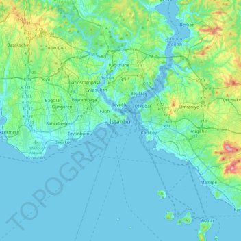
Name: Istanbul topographic map, elevation, terrain.
Location: Istanbul, Fatih, İstanbul, Région de Marmara, 34127, Turquie (40.84920 28.80622 41.16920 29.12622)
Average elevation: 55 m
Minimum elevation: -2 m
Maximum elevation: 429 m
Other topographic maps
Click on a map to view its topography, its elevation and its terrain.
Balat Mahallesi
Balat Mahallesi, Fatih, İstanbul, Marmara Bölgesi, Turquie
Average elevation: 34 m