
Larkhill topographic map
Interactive map
Click on the map to display elevation.
About this map
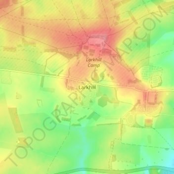
Name: Larkhill topographic map, elevation, terrain.
Location: Larkhill, Wiltshire, Inghilterra, SP4 8QB, Regno Unito (51.17648 -1.83763 51.21648 -1.79763)
Average elevation: 111 m
Minimum elevation: 69 m
Maximum elevation: 150 m
Other topographic maps
Click on a map to view its topography, its elevation and its terrain.
Beckhampton
Regno Unito > Inghilterra > Wiltshire
Beckhampton, Avebury, Wiltshire, Inghilterra, SN8 1QL, Regno Unito
Average elevation: 170 m
West Amesbury
Regno Unito > Inghilterra > Wiltshire
West Amesbury, Wiltshire, Inghilterra, SP4 7BH, Regno Unito
Average elevation: 90 m