
Beckhampton topographic map
Interactive map
Click on the map to display elevation.
About this map
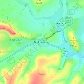
Name: Beckhampton topographic map, elevation, terrain.
Average elevation: 170 m
Minimum elevation: 146 m
Maximum elevation: 215 m
Other topographic maps
Click on a map to view its topography, its elevation and its terrain.
West Amesbury
Regno Unito > Inghilterra > Wiltshire
West Amesbury, Wiltshire, Inghilterra, SP4 7BH, Regno Unito
Average elevation: 90 m
Larkhill
Regno Unito > Inghilterra > Wiltshire
Larkhill, Wiltshire, Inghilterra, SP4 8QB, Regno Unito
Average elevation: 111 m