
Aughnagurgan topographic map
Interactive map
Click on the map to display elevation.
About this map
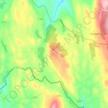
Name: Aughnagurgan topographic map, elevation, terrain.
Location: Aughnagurgan, Northern Ireland, United Kingdom (54.17928 -6.68171 54.23543 -6.64377)
Average elevation: 221 m
Minimum elevation: 139 m
Maximum elevation: 327 m
Other topographic maps
Click on a map to view its topography, its elevation and its terrain.
Rock Cottage
United Kingdom > Northern Ireland > County Antrim
Rock Cottage, County Antrim, Northern Ireland, BT57 8XY, United Kingdom
Average elevation: 117 m
Ballylesson
United Kingdom > Northern Ireland > County Down
Ballylesson, County Down, Northern Ireland, BT8 8JU, United Kingdom
Average elevation: 61 m
The Dark Hedges
United Kingdom > Northern Ireland > County Antrim
The Dark Hedges, County Antrim, Ulster, Northern Ireland, BT53 8RS, United Kingdom
Average elevation: 74 m
Inish Free
United Kingdom > Northern Ireland > County Fermanagh
Inish Free, County Fermanagh, Northern Ireland, United Kingdom
Average elevation: 47 m
Islandmagee
United Kingdom > Northern Ireland > Islandmagee
Islandmagee, County Antrim, Northern Ireland, BT40 3SH, United Kingdom
Average elevation: 23 m
Lisnarrick
United Kingdom > Northern Ireland > Lisnarrick
Lisnarrick, County Fermanagh, Northern Ireland, BT9 3WB, United Kingdom
Average elevation: 68 m
Aghalislone
United Kingdom > Northern Ireland > Lisburn
Aghalislone, Lisburn, County Antrim, Northern Ireland, United Kingdom
Average elevation: 139 m
Slieve Donard
United Kingdom > Northern Ireland
Slieve Donard, County Down, Northern Ireland, BT33 0HD, United Kingdom
Average elevation: 503 m
Black Mountain
United Kingdom > Northern Ireland > Lisburn
Black Mountain, Lisburn, County Antrim, Northern Ireland, BT11 8BU, United Kingdom
Average elevation: 232 m
Mourne Mountains West
United Kingdom > Northern Ireland
Mourne Mountains West, County Down, Northern Ireland, United Kingdom
Average elevation: 272 m