
São Julião topographic map
Interactive map
Click on the map to display elevation.
About this map
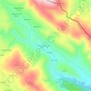
Name: São Julião topographic map, elevation, terrain.
Location: São Julião, Portalegre, 7300-459, Portugal (39.29032 -7.32018 39.33032 -7.28018)
Average elevation: 645 m
Minimum elevation: 427 m
Maximum elevation: 929 m
Other topographic maps
Click on a map to view its topography, its elevation and its terrain.
Telhada
Portugal > Portalegre > Portalegre > Telhada
Telhada, Alegrete, Portalegre, Alentejo, 7300-311, Portugal
Average elevation: 575 m