
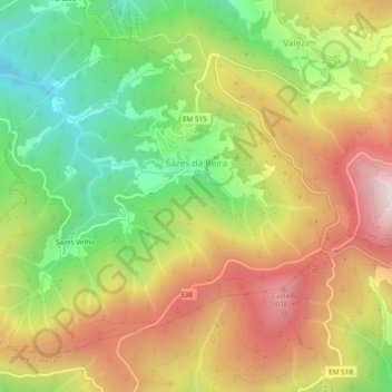
Sazes da Beira topographic map
Interactive map
Click on the map to display elevation.
About this map
Name: Sazes da Beira topographic map, elevation, terrain.
Location: Sazes da Beira, Seia, Guarda, Portugal (40.33045 -7.76302 40.35963 -7.71536)
Average elevation: 766 m
Minimum elevation: 397 m
Maximum elevation: 1,163 m
Other topographic maps
Click on a map to view its topography, its elevation and its terrain.
Travancinha
Travancinha, Seia, Guarda, 6270-605, Portugal
Average elevation: 386 m
Carragozela
Carragozela, Seia, Guarda, 6270-584, Portugal
Average elevation: 474 m
Serra da Estrela
Serra da Estrela, Seia, Guarda, Portugal
Average elevation: 1,825 m