
Frederick County topographic map
Interactive map
Click on the map to display elevation.
About this map
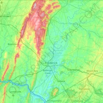
Name: Frederick County topographic map, elevation, terrain.
Location: Frederick County, Maryland, USA (39.21961 -77.67736 39.72003 -77.10673)
Average elevation: 185 m
Minimum elevation: 60 m
Maximum elevation: 645 m
Other topographic maps
Click on a map to view its topography, its elevation and its terrain.
Patapsco Woods
USA > Maryland > Patapsco Woods
Patapsco Woods, Carroll County, Maryland, 21048, USA
Average elevation: 183 m
Cockeysville
USA > Maryland > Cockeysville
Cockeysville, Baltimore County, Maryland, 21031, USA
Average elevation: 131 m