
Thank you for supporting this site ❤️
Make a donation
Make a donation
Sumoto topographic map
Click on the map to display elevation.
Thank you for supporting this site ❤️
Make a donation
Make a donation
About this map
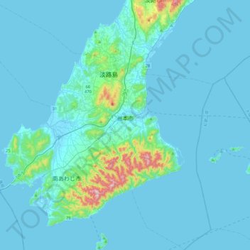
Name: Sumoto topographic map, elevation, terrain.
Location: Sumoto, Hyogo Prefecture, Japan (34.15630 134.59395 34.50086 135.00715)
Average elevation: 41 m
Minimum elevation: -2 m
Maximum elevation: 582 m
Thank you for supporting this site ❤️
Make a donation
Make a donation
Other topographic maps
Click on a map to view its topography, its elevation and its terrain.