
Kanyamazane topographic map
Click on the map to display elevation.
About this map
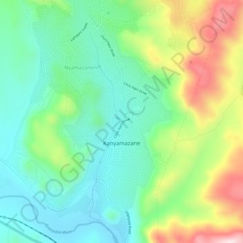
Name: Kanyamazane topographic map, elevation, terrain.
Average elevation: 637 m
Minimum elevation: 476 m
Maximum elevation: 972 m
Other topographic maps
Click on a map to view its topography, its elevation and its terrain.
White River
South Africa > Mpumalanga > Ehlanzeni District Municipality > Mbombela
White River is located in the low altitude subtropical Lowveld climatic zone. Savannah and woodland scattered with granite outcrops form the indigenous habitat. Compared to other parts of South Africa, the climate is mild with good rainfall. Nevertheless, like the rest of South Africa, White River and its…
Average elevation: 902 m
Hazyview
South Africa > Mpumalanga > Ehlanzeni District Municipality > Mbombela
Average elevation: 554 m
Kamsogwaba
South Africa > Mpumalanga > Ehlanzeni District Municipality > Mbombela
Average elevation: 570 m
Kaapsehoop
South Africa > Mpumalanga > Ehlanzeni District Municipality > Mbombela
Average elevation: 1,505 m
Skukuza Rest Camp
South Africa > Mpumalanga > Ehlanzeni District Municipality > Mbombela
Average elevation: 282 m
Kamagugu
South Africa > Mpumalanga > Ehlanzeni District Municipality > Mbombela
Average elevation: 685 m
Berg-en-Dal Rest Camp
South Africa > Mpumalanga > Ehlanzeni District Municipality > Mbombela
Average elevation: 399 m
Kiepersol
South Africa > Mpumalanga > Ehlanzeni District Municipality > Mbombela
Average elevation: 755 m
Sudwala Caves
South Africa > Mpumalanga > Ehlanzeni District Municipality > Mbombela
Average elevation: 995 m
Salubindza
South Africa > Mpumalanga > Ehlanzeni District Municipality > Mbombela
Average elevation: 676 m
Nsikazi
South Africa > Mpumalanga > Ehlanzeni District Municipality > Mbombela
Average elevation: 472 m
eMbonisweni
South Africa > Mpumalanga > Ehlanzeni District Municipality > Mbombela
Average elevation: 674 m
Tshabalala
South Africa > Mpumalanga > Ehlanzeni District Municipality > Mbombela
Average elevation: 559 m
Matsulu
South Africa > Mpumalanga > Ehlanzeni District Municipality > Mbombela
Average elevation: 449 m
Matsulu
South Africa > Mpumalanga > Ehlanzeni District Municipality > Mbombela
Average elevation: 449 m
Matsulu
South Africa > Mpumalanga > Ehlanzeni District Municipality > Mbombela
Average elevation: 449 m
Kaapsehoop
South Africa > Mpumalanga > Ehlanzeni District Municipality > Mbombela
Average elevation: 1,505 m
White River
South Africa > Mpumalanga > Ehlanzeni District Municipality > Mbombela
White River is located in the low altitude subtropical Lowveld climatic zone. Savannah and woodland scattered with granite outcrops form the indigenous habitat. Compared to other parts of South Africa, the climate is mild with good rainfall. Nevertheless, like the rest of South Africa, White River and its…
Average elevation: 902 m
Matsulu
South Africa > Mpumalanga > Ehlanzeni District Municipality > Mbombela
Average elevation: 449 m
Hazyview
South Africa > Mpumalanga > Ehlanzeni District Municipality > Mbombela
Average elevation: 554 m
White River
South Africa > Mpumalanga > Ehlanzeni District Municipality > Mbombela
White River is located in the low altitude subtropical Lowveld climatic zone. Savannah and woodland scattered with granite outcrops form the indigenous habitat. Compared to other parts of South Africa, the climate is mild with good rainfall. Nevertheless, like the rest of South Africa, White River and its…
Average elevation: 902 m
Skukuza Rest Camp
South Africa > Mpumalanga > Ehlanzeni District Municipality > Mbombela
Average elevation: 282 m
Sudwala Caves
South Africa > Mpumalanga > Ehlanzeni District Municipality > Mbombela
Average elevation: 995 m
Hazyview
South Africa > Mpumalanga > Ehlanzeni District Municipality > Mbombela > Hazyview
Average elevation: 554 m