
Clausen topographic map
Interactive map
Click on the map to display elevation.
About this map
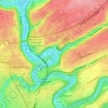
Name: Clausen topographic map, elevation, terrain.
Location: Clausen, Luxembourg, Canton Luxembourg, Luxembourg (49.61060 6.13604 49.61849 6.14797)
Average elevation: 300 m
Minimum elevation: 238 m
Maximum elevation: 350 m
Other topographic maps
Click on a map to view its topography, its elevation and its terrain.
Ville-Haute
Ville-Haute, Luxembourg, Canton Luxembourg, Luxembourg
Average elevation: 295 m
Cessange
Cessange, Luxembourg, Canton Luxembourg, Luxembourg
Average elevation: 291 m
Château de Septfontaines
Château de Septfontaines, Rue de Rollingergrund, Rollingergrund, Luxembourg, Canton Luxembourg, 2621, Luxembourg
Average elevation: 316 m