
Thank you for supporting this site ❤️
Make a donation
Make a donation
Hurungwe topographic map
Click on the map to display elevation.
Thank you for supporting this site ❤️
Make a donation
Make a donation
About this map
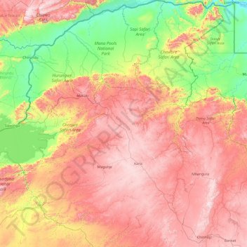
Name: Hurungwe topographic map, elevation, terrain.
Location: Hurungwe, Mashonaland West Province, Zimbabwe (-17.43633 28.82037 -15.60970 30.33928)
Average elevation: 826 m
Minimum elevation: 325 m
Maximum elevation: 1,459 m
Thank you for supporting this site ❤️
Make a donation
Make a donation
Other topographic maps
Click on a map to view its topography, its elevation and its terrain.
Kadoma
Zimbabwe > Mashonaland West Province > Kadoma
The city is located in Kadoma District, Mashonaland West Province, one of the 10 administrative provinces in Zimbabwe. This location lies approximately 141 kilometres (88 mi), by road, southwest of Harare, the national capital and largest city in the country. The city lies on Highway A-5, between Harare and…
Average elevation: 1,134 m