
Hluhluwe-iMfolozi Park topographic map
Interactive map
Click on the map to display elevation.
Hluhluwe-iMfolozi Park
Hluhluwe–Imfolozi Park, formerly Hluhluwe–Umfolozi Game Reserve, is the oldest proclaimed nature reserve in Africa. It consists of 960 km² (96,000 ha) of hilly topography 280 kilometres (170 mi) north of Durban in central KwaZulu-Natal, South Africa and is known for its rich wildlife and conservation efforts. Operated by Ezemvelo KZN Wildlife, the park is the only state-run park in KwaZulu-Natal where each of the big five game animals can be found.
About this map
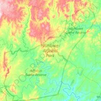
Name: Hluhluwe-iMfolozi Park topographic map, elevation, terrain.
Average elevation: 238 m
Minimum elevation: 24 m
Maximum elevation: 776 m
Other topographic maps
Click on a map to view its topography, its elevation and its terrain.
Ingwavuma
South Africa > KwaZulu-Natal > Umkhanyakude District Municipality > Jozini Local Municipality
Average elevation: 500 m
Mtubatuba
South Africa > KwaZulu-Natal > Umkhanyakude District Municipality > Mtubatuba Local Municipality
Average elevation: 64 m
Dukuduku
South Africa > KwaZulu-Natal > Umkhanyakude District Municipality > Mtubatuba Local Municipality
Average elevation: 39 m
Mtubatuba
South Africa > KwaZulu-Natal > Umkhanyakude District Municipality > Mtubatuba Local Municipality
Average elevation: 64 m
Cape Vidal
South Africa > KwaZulu-Natal > Umkhanyakude District Municipality > Mtubatuba Local Municipality
Average elevation: 19 m
Sodwana Bay
South Africa > KwaZulu-Natal > Umkhanyakude District Municipality > The Big Five False Bay Local Municipality
Average elevation: 16 m
Mtubatuba
South Africa > KwaZulu-Natal > Umkhanyakude District Municipality > Mtubatuba Local Municipality
Average elevation: 64 m
Hlabisa
South Africa > KwaZulu-Natal > Umkhanyakude District Municipality > Hlabisa Local Municipality
Average elevation: 482 m
Hlabisa
South Africa > KwaZulu-Natal > Umkhanyakude District Municipality > Hlabisa Local Municipality
Average elevation: 482 m
Manguzi
South Africa > KwaZulu-Natal > Umkhanyakude District Municipality > uMhlabuyalingana Local Municipality
Average elevation: 44 m
Hluhluwe
South Africa > KwaZulu-Natal > Umkhanyakude District Municipality > The Big Five False Bay Local Municipality
Average elevation: 71 m
St. Lucia
South Africa > KwaZulu-Natal > Umkhanyakude District Municipality > Mtubatuba Local Municipality > St. Lucia
Average elevation: 8 m
Hluhluwe
South Africa > KwaZulu-Natal > Umkhanyakude District Municipality > The Big Five False Bay Local Municipality
Average elevation: 71 m