Geolocate

Middlechurch topographic map

Click on the map to display elevation.

About this map

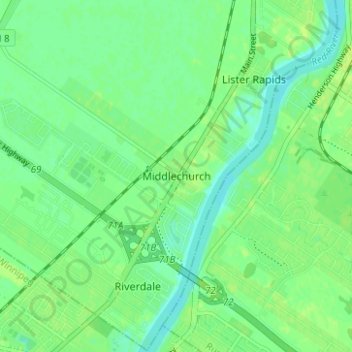
Name: Middlechurch topographic map, elevation, terrain.

Location: Middlechurch, Rural Municipality of West St. Paul, Manitoba, R4A 5A3, Canada (49.95977 -97.08780 49.99977 -97.04780)

Average elevation: 231 m

Minimum elevation: 224 m

Maximum elevation: 236 m

Other topographic maps

Click on a map to view its topography, its elevation and its terrain.

Winnipeg

Canada > Manitoba

Winnipeg lies at the bottom of the Red River Valley, a flood plain with an extremely flat topography. It is on the eastern edge of the Canadian Prairies in Western Canada and is known as the "Gateway to the West". Winnipeg is bordered by tallgrass prairie to the west and south and the aspen parkland to the…

Average elevation: 236 m

Assiniboine River

Canada > Manitoba

Average elevation: 481 m

Lake Manitoba

Canada > Manitoba

Average elevation: 298 m

Lake Winnipeg

Canada > Manitoba

Average elevation: 275 m

Neepawa

Canada > Manitoba

Average elevation: 370 m

Rural Municipality of Dauphin

Canada > Manitoba

Average elevation: 321 m

Municipality of Rhineland

Canada > Manitoba

Average elevation: 254 m

Winnipeg River

Canada > Manitoba

Average elevation: 309 m

Brandon

Canada > Manitoba > Brandon

Average elevation: 393 m

Riding Mountain National Park

Canada > Manitoba > Dauphin

The climate in the Riding Mountain region is similar to that of other regions of southwestern Manitoba. Under the Köppen classification it has a continental climate. It includes grasslands, upland boreal and eastern deciduous forest ecosystems. The park has hot summers and cold winters, with annual rainfall…

Average elevation: 488 m

St. François Xavier

Canada > Manitoba

Average elevation: 243 m

Turtle Mountain Provincial Park

Canada > Manitoba > Municipality of Boissevain – Morton

Turtle Mountain Provincial Park is situated on the Turtle Mountain (plateau), one of a number of significant geographic features located along the Manitoba Escarpment, the Canadian portion of the Pembina Escarpment. It is located in the Southwest Manitoba Uplands Ecoregion, within the Canadian Prairies. The…

Average elevation: 662 m

Hayes River

Canada > Manitoba

Average elevation: 163 m

Unorganized Division No. 19

Canada > Manitoba

Average elevation: 291 m

Lake of the Prairies

Canada > Manitoba

Average elevation: 502 m

Riding Mountain National Park

Canada > Manitoba > Municipality of Harrison Park > Wasagaming

Riding Mountain Biosphere Reserve covers 15,000 square kilometers of land in South-western Manitoba, with the core area, Riding Mountain National Park (RMNP), covering nearly 3,000 square kilometers. It is some 300 km northwest of Winnipeg, Manitoba. The local climate is cool and moist due to a higher…

Average elevation: 623 m

Morden

Canada > Manitoba

Average elevation: 308 m

Valley River

Canada > Manitoba

Average elevation: 496 m

Lynn Lake

Canada > Manitoba

Average elevation: 353 m

Unorganized Division No. 19

Canada > Manitoba

Average elevation: 291 m

Flin Flon

Canada > Manitoba

Average elevation: 323 m

Leaf Rapids

Canada > Manitoba

Average elevation: 291 m

Carberry

Canada > Manitoba

Average elevation: 385 m

Melita

Canada > Manitoba

Average elevation: 440 m

Gilbert Plains Municipality

Canada > Manitoba

Average elevation: 412 m

Municipality of Lorne

Canada > Manitoba

Average elevation: 440 m

Churchill

Canada > Manitoba

Average elevation: 5 m

Rural Municipality of Rosser

Canada > Manitoba

Average elevation: 241 m

Athapapuskow Lake

Canada > Manitoba

Average elevation: 306 m

Carberry

Canada > Manitoba

Average elevation: 385 m

Grandview Municipality

Canada > Manitoba

Average elevation: 514 m

Powerview-Pine Falls

Canada > Manitoba

Average elevation: 227 m

Stonewall

Canada > Manitoba

When the last ice age retreated, as well as the prairies, escarpments such as Riding Mountain were left behind. In addition to these, smaller elevations were left behind such as Stony Mountain and Stonewall. It is believed that these escarpments were used as look-outs by early hunters approximately 4,000 to…

Average elevation: 251 m

Brandon

Canada > Manitoba

Average elevation: 394 m

Rock Lake

Canada > Manitoba > Unorganized Division No. 1

Average elevation: 338 m

Pelican Lake

Canada > Manitoba > Municipality of Killarney-Turtle Mountain

The lake is normally maintained at elevations between 411.5 and 412 metres (1,350 and 1,352 ft) above sea level during summer months. During the spring period, the lake may be raised temporarily to an elevation of 412.2 metres (1,352 ft). When the lake is low, water may be diverted from the Pembina River into…

Average elevation: 459 m

Louise Lake

Canada > Manitoba > Lynn Lake

Average elevation: 382 m

Municipality of Roblin

Canada > Manitoba

Average elevation: 594 m

Edgewood Park

Canada > Manitoba > Winnipeg

Average elevation: 234 m

Municipality of Louise

Canada > Manitoba

Average elevation: 462 m

Bison Run

Canada > Manitoba > Winnipeg

Average elevation: 234 m

Unorganized Division No. 23

Canada > Manitoba

Average elevation: 218 m

Winnipeg

Canada > Manitoba

Winnipeg lies at the bottom of the Red River Valley, a flood plain with an extremely flat topography. It is on the eastern edge of the Canadian Prairies in Western Canada and is known as the "Gateway to the West". Winnipeg is bordered by tallgrass prairie to the west and south and the aspen parkland to the…

Average elevation: 236 m

Maple Grove Park

Canada > Manitoba > Winnipeg

Average elevation: 233 m

Municipality of Lorne

Canada > Manitoba

Average elevation: 440 m

Toilers Memorial Park

Canada > Manitoba > Winnipeg

Average elevation: 234 m

Beaumont

Canada > Manitoba > Winnipeg

Average elevation: 234 m

Altona

Canada > Manitoba

Average elevation: 248 m

Winnipeg

Canada > Manitoba

Winnipeg lies at the bottom of the Red River Valley, a flood plain with an extremely flat topography. It is on the eastern edge of the Canadian Prairies in Western Canada and is known as the "Gateway to the West". Winnipeg is bordered by tallgrass prairie to the west and south and the aspen parkland to the…

Average elevation: 236 m

Swan River

Canada > Manitoba

Average elevation: 338 m

Selkirk

Canada > Manitoba

Average elevation: 227 m

Flin Flon

Canada > Manitoba

Average elevation: 322 m