
Make a donation
Winnipeg topographic map
Click on the map to display elevation.
Make a donation
Winnipeg
Winnipeg lies at the bottom of the Red River Valley, a flood plain with an extremely flat topography. It is on the eastern edge of the Canadian Prairies in Western Canada and is known as the "Gateway to the West". Winnipeg is bordered by tallgrass prairie to the west and south and the aspen parkland to the northeast, although most of the native prairie grasses have been removed for agriculture and urbanization. It is relatively close to many large Canadian Shield lakes and parks, as well as Lake Winnipeg (the Earth's 11th largest freshwater lake). Winnipeg has North America's largest extant mature urban elm forest. The city has an area of 464.08 km2 (179.18 sq mi).
Make a donation
About this map
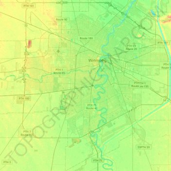
Name: Winnipeg topographic map, elevation, terrain.
Location: Winnipeg, Manitoba, Canada (49.71355 -97.34915 49.99401 -96.95653)
Average elevation: 236 m
Minimum elevation: 222 m
Maximum elevation: 261 m
Make a donation
Other topographic maps
Click on a map to view its topography, its elevation and its terrain.
Make a donation
Bella Coola
Canada > British Columbia > Central Coast Regional District > Area E (West Bella Coola/Clayton Falls/Tallheo)
There is a 454 km mostly paved road connection by Highway 20 to Williams Lake. The 137 kilometre section from Bella Coola to Anahim Lake was built in 1953 by local residents, and features a 15 km ascent from the Valley floor to the Chilcotin plateau, gaining 1600 metres in elevation to the summit at Heckman…
Average elevation: 437 m
Make a donation
Silver Lakes
Canada > British Columbia > Peace River Regional District > Area B (Finlay Valley/Beatton Valley)
Average elevation: 847 m
Salmon River
Canada > British Columbia > Metro Vancouver Regional District > Township of Langley
Average elevation: 24 m
Interior Plateau
Canada > British Columbia > Regional District of Bulkley-Nechako > Area E (Ootsa Lake/François Lake)
Average elevation: 896 m
Make a donation
Maxville
Canada > Ontario > Stormont, Dundas and Glengarry Counties > North Glengarry
Average elevation: 100 m
Make a donation
Make a donation
Anahim Lake
Canada > British Columbia > Cariboo Regional District > Area J (West Chilcotin)
Average elevation: 1,101 m
Elk River
Canada > British Columbia > Regional District of East Kootenay > Fernie
Average elevation: 1,134 m
Make a donation
Make a donation
Make a donation
Enderby
Canada > British Columbia > Regional District of North Okanagan > Enderby > Enderby
Latitude-Longitude: 50°33′03.0″N 119°08′22.7″W / 50.550833°N 119.139639°W / 50.550833; -119.139639 elevation: 360 metres
Average elevation: 511 m
Grindrod
Canada > British Columbia > Regional District of North Okanagan > Area F (Grindrod/Ashton Creek/Mabel Lake) > Grindrod
Average elevation: 406 m
Parc Herbert-Brown-Ames
Canada > Quebec > Urban agglomeration of Montreal > Montreal
Average elevation: 32 m
Make a donation
Tower Island
Canada > Ontario > Kenora District > Unorganized Kenora District
Average elevation: 349 m