
Make a donation
Mzumbe topographic map
Click on the map to display elevation.
Make a donation
About this map
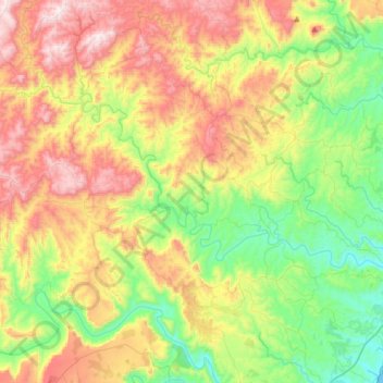
Name: Mzumbe topographic map, elevation, terrain.
Average elevation: 332 m
Minimum elevation: 0 m
Maximum elevation: 823 m
Make a donation
Other topographic maps
Click on a map to view its topography, its elevation and its terrain.
uMdoni Local Municipality
South Africa > KwaZulu-Natal > Ugu District Municipality
Average elevation: 129 m
Port Edward
South Africa > KwaZulu-Natal > Ugu District Municipality > Hibiscus Coast Local Municipality
Average elevation: 42 m
Port Shepstone
South Africa > KwaZulu-Natal > Ugu District Municipality > Hibiscus Coast Local Municipality
Port Shepstone's topography is characterised by a rugged/hilly terrain with the Central Business District (CBD) lying on a large hill overlooking the Indian Ocean. Port Shepstone proper (excluding its extensions) is bordered by the uMzimkhulu River to the north and the N2 freeway to the east and is also…
Average elevation: 33 m
Umzumbe Local Municipality
South Africa > KwaZulu-Natal > Ugu District Municipality
Average elevation: 417 m
Make a donation
Hibiscus Coast Local Municipality
South Africa > KwaZulu-Natal > Ugu District Municipality
Average elevation: 204 m
Umzimkulu River
South Africa > KwaZulu-Natal > Ugu District Municipality > Hibiscus Coast Local Municipality > Port Shepstone
Average elevation: 135 m
Ramsgate
South Africa > KwaZulu-Natal > Ugu District Municipality > Hibiscus Coast Local Municipality
Average elevation: 29 m
Make a donation
Oribi Gorge Nature Reserve
South Africa > KwaZulu-Natal > Ugu District Municipality > Ezinqoleni Local Municipality
Average elevation: 430 m
Shelly Beach
South Africa > KwaZulu-Natal > Ugu District Municipality > Hibiscus Coast Local Municipality
Average elevation: 25 m
Southbroom
South Africa > KwaZulu-Natal > Ugu District Municipality > Hibiscus Coast Local Municipality
Average elevation: 30 m
Izingolweni
South Africa > KwaZulu-Natal > Ugu District Municipality > Ezinqoleni Local Municipality
Average elevation: 552 m
Make a donation
Glenmore
South Africa > KwaZulu-Natal > Ugu District Municipality > Hibiscus Coast Local Municipality
Average elevation: 36 m
Umtentweni
South Africa > KwaZulu-Natal > Ugu District Municipality > Hibiscus Coast Local Municipality
Average elevation: 32 m
Harding
South Africa > KwaZulu-Natal > Ugu District Municipality > uMuziwabantu Local Municipality
Average elevation: 878 m
Vulamehlo Local Municipality
South Africa > KwaZulu-Natal > Ugu District Municipality
Average elevation: 421 m
Make a donation
Scottburgh
South Africa > KwaZulu-Natal > Ugu District Municipality > uMdoni Local Municipality
Average elevation: 36 m
Palm Beach
South Africa > KwaZulu-Natal > Ugu District Municipality > Hibiscus Coast Local Municipality
Average elevation: 31 m
Margate
South Africa > KwaZulu-Natal > Ugu District Municipality > Hibiscus Coast Local Municipality
Average elevation: 45 m
uMdoni Local Municipality
South Africa > KwaZulu-Natal > Ugu District Municipality
Average elevation: 129 m
Make a donation
Anerley
South Africa > KwaZulu-Natal > Ugu District Municipality > Hibiscus Coast Local Municipality
Average elevation: 25 m
Izingolweni
South Africa > KwaZulu-Natal > Ugu District Municipality > Ezinqoleni Local Municipality
Average elevation: 552 m
Harding
South Africa > KwaZulu-Natal > Ugu District Municipality > uMuziwabantu Local Municipality
Average elevation: 878 m
Scottburgh
South Africa > KwaZulu-Natal > Ugu District Municipality > uMdoni Local Municipality
Average elevation: 36 m
Make a donation
Weza Forest
South Africa > KwaZulu-Natal > Ugu District Municipality > uMuziwabantu Local Municipality
Areas of forest which grow in KwaZulu-Natal, South Africa mostly on south facing slopes in higher rainfall areas, and along the humid coastal areas. Different types of forest can be identified by their species composition which depends mostly on the altitude, latitude and substrate (soil and rock types) in…
Average elevation: 1,317 m
Hibiscus Coast Local Municipality
South Africa > KwaZulu-Natal > Ugu District Municipality
Average elevation: 204 m
Oribi Gorge Nature Reserve
South Africa > KwaZulu-Natal > Ugu District Municipality > Ezinqoleni Local Municipality
Average elevation: 430 m
Port Edward
South Africa > KwaZulu-Natal > Ugu District Municipality > Hibiscus Coast Local Municipality
Average elevation: 42 m
Make a donation
Hibiscus Coast Local Municipality
South Africa > KwaZulu-Natal > Ugu District Municipality
Average elevation: 204 m
Ezinqoleni Local Municipality
South Africa > KwaZulu-Natal > Ugu District Municipality
Average elevation: 437 m
Margate
South Africa > KwaZulu-Natal > Ugu District Municipality > Hibiscus Coast Local Municipality
Average elevation: 45 m
Vulamehlo Local Municipality
South Africa > KwaZulu-Natal > Ugu District Municipality
Average elevation: 421 m
Make a donation
uMdoni Local Municipality
South Africa > KwaZulu-Natal > Ugu District Municipality
Average elevation: 129 m
Palm Beach
South Africa > KwaZulu-Natal > Ugu District Municipality > Hibiscus Coast Local Municipality
Average elevation: 31 m