
Rhodes topographic map
Click on the map to display elevation.
About this map
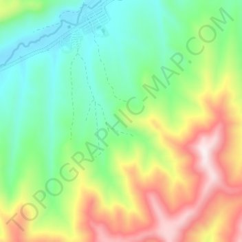
Name: Rhodes topographic map, elevation, terrain.
Average elevation: 2,067 m
Minimum elevation: 1,798 m
Maximum elevation: 2,530 m
Other topographic maps
Click on a map to view its topography, its elevation and its terrain.
Barkly East
South Africa > Eastern Cape > Joe Gqabi District Municipality > Senqu Local Municipality
Barkly East (Afrikaans: Barkly-Oos) is a town in Eastern Cape Province, South Africa, seat of the Joe Gqabi District Municipality, and 117 km by road E.S.E. of Aliwal North, lying in the mountainous area just south of Lesotho. The town lies at the southern tip of the Drakensberg on the Langkloofspruit, a…
Average elevation: 1,838 m
Sterkspruit
South Africa > Eastern Cape > Joe Gqabi District Municipality > Senqu Local Municipality
Average elevation: 1,486 m
Sterkspruit
South Africa > Eastern Cape > Joe Gqabi District Municipality > Senqu Local Municipality
Average elevation: 1,486 m
Naledi
South Africa > Eastern Cape > Joe Gqabi District Municipality > Senqu Local Municipality
Average elevation: 1,518 m
Sterkspruit
South Africa > Eastern Cape > Joe Gqabi District Municipality > Senqu Local Municipality
Average elevation: 1,486 m
Lady Grey
South Africa > Eastern Cape > Joe Gqabi District Municipality > Senqu Local Municipality
Average elevation: 1,803 m
Ekhephini (Barkly East)
South Africa > Eastern Cape > Joe Gqabi District Municipality > Senqu Local Municipality
Barkly East (Afrikaans: Barkly-Oos) is a town in Eastern Cape Province, South Africa, seat of the Joe Gqabi District Municipality, and 117 km by road E.S.E. of Aliwal North, lying in the mountainous area just south of Lesotho. The town lies at the southern tip of the Drakensberg on the Langkloofspruit, a…
Average elevation: 1,839 m
Barkly East
South Africa > Eastern Cape > Joe Gqabi District Municipality > Senqu Local Municipality
Barkly East (Afrikaans: Barkly-Oos) is a town in Eastern Cape Province, South Africa, seat of the Joe Gqabi District Municipality, and 117 km by road E.S.E. of Aliwal North, lying in the mountainous area just south of Lesotho. The town lies at the southern tip of the Drakensberg on the Langkloofspruit, a…
Average elevation: 1,838 m
Naledi
South Africa > Eastern Cape > Joe Gqabi District Municipality > Senqu Local Municipality
Average elevation: 1,518 m