
Make a donation
Umgeni River topographic map
Click on the map to display elevation.
Make a donation
About this map
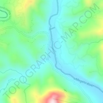
Name: Umgeni River topographic map, elevation, terrain.
Average elevation: 342 m
Minimum elevation: 240 m
Maximum elevation: 652 m
Make a donation
Other topographic maps
Click on a map to view its topography, its elevation and its terrain.
eThekwini Ward 99
South Africa > KwaZulu-Natal > eThekwini Metropolitan Municipality
Average elevation: 97 m
eThekwini Ward 97
South Africa > KwaZulu-Natal > eThekwini Metropolitan Municipality
Average elevation: 42 m
Shongweni Dam
South Africa > KwaZulu-Natal > eThekwini Metropolitan Municipality
Average elevation: 377 m
uMhlangane River
South Africa > KwaZulu-Natal > eThekwini Metropolitan Municipality > KwaMashu
Average elevation: 95 m
Make a donation
eThekwini Ward 25
South Africa > KwaZulu-Natal > eThekwini Metropolitan Municipality
Average elevation: 72 m
Natal Bay
South Africa > KwaZulu-Natal > eThekwini Metropolitan Municipality > Durban
Average elevation: 4 m