
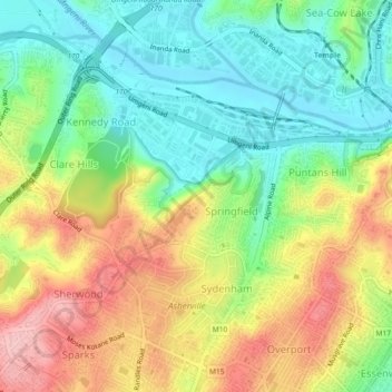
eThekwini Ward 25 topographic map
Interactive map
Click on the map to display elevation.
About this map
Name: eThekwini Ward 25 topographic map, elevation, terrain.
Average elevation: 72 m
Minimum elevation: 2 m
Maximum elevation: 168 m
Other topographic maps
Click on a map to view its topography, its elevation and its terrain.
Durban
South Africa > KwaZulu-Natal > eThekwini Metropolitan Municipality
Durban, eThekwini Metropolitan Municipality, KwaZulu-Natal, 4057, South Africa
Average elevation: 83 m
Hillcrest
South Africa > KwaZulu-Natal > eThekwini Metropolitan Municipality
Hillcrest, eThekwini Metropolitan Municipality, KwaZulu-Natal, 3651, South Africa
Average elevation: 625 m
Umlazi
South Africa > KwaZulu-Natal > eThekwini Metropolitan Municipality
Umlazi, eThekwini Metropolitan Municipality, KwaZulu-Natal, 4066, South Africa
Average elevation: 100 m
Umkomaas
South Africa > KwaZulu-Natal > eThekwini Metropolitan Municipality
Umkomaas, eThekwini Metropolitan Municipality, KwaZulu-Natal, 4170, South Africa
Average elevation: 38 m
Umbilo River
South Africa > KwaZulu-Natal > eThekwini Metropolitan Municipality
Umbilo River, Westmead, eThekwini Ward 15, eThekwini Metropolitan Municipality, KwaZulu-Natal, 3610, South Africa
Average elevation: 372 m
Molweni River
South Africa > KwaZulu-Natal > eThekwini Metropolitan Municipality
Molweni River, Emberton, eThekwini Ward 10, eThekwini Metropolitan Municipality, KwaZulu-Natal, 3603, South Africa
Average elevation: 603 m
Blue Lagoon
South Africa > KwaZulu-Natal > eThekwini Metropolitan Municipality > Durban
Blue Lagoon, eThekwini Ward 27, Durban, eThekwini Metropolitan Municipality, KwaZulu-Natal, South Africa
Average elevation: 16 m
Umgeni River
South Africa > KwaZulu-Natal > eThekwini Metropolitan Municipality > Queensburgh
Umgeni River, Malvern, eThekwini Ward 63, Queensburgh, eThekwini Metropolitan Municipality, KwaZulu-Natal, 4093, South Africa
Average elevation: 149 m
Mpumalanga
South Africa > KwaZulu-Natal > eThekwini Metropolitan Municipality
Mpumalanga, eThekwini Metropolitan Municipality, KwaZulu-Natal, South Africa
Average elevation: 582 m
Umbilo River
South Africa > KwaZulu-Natal > eThekwini Metropolitan Municipality > Durban
Umbilo River, Hillary, eThekwini Ward 65, Durban, eThekwini Metropolitan Municipality, KwaZulu-Natal, 4094, South Africa
Average elevation: 69 m
Pinetown
South Africa > KwaZulu-Natal > eThekwini Metropolitan Municipality
Pinetown, eThekwini Metropolitan Municipality, KwaZulu-Natal, 3600, South Africa
Average elevation: 296 m
Molweni River
South Africa > KwaZulu-Natal > eThekwini Metropolitan Municipality > Forest Hills
Molweni River, eThekwini Ward 9, Forest Hills, eThekwini Metropolitan Municipality, KwaZulu-Natal, 3625, South Africa
Average elevation: 227 m
Umdloti / eMdloti
South Africa > KwaZulu-Natal > eThekwini Metropolitan Municipality
Umdloti / eMdloti, eThekwini Metropolitan Municipality, KwaZulu-Natal, 4350, South Africa
Average elevation: 38 m
Chatsworth
South Africa > KwaZulu-Natal > eThekwini Metropolitan Municipality
Chatsworth, eThekwini Metropolitan Municipality, KwaZulu-Natal, 4030, South Africa
Average elevation: 149 m
Kloof
South Africa > KwaZulu-Natal > eThekwini Metropolitan Municipality
Kloof, eThekwini Metropolitan Municipality, KwaZulu-Natal, 3625, South Africa
Average elevation: 480 m
Durban North
South Africa > KwaZulu-Natal > eThekwini Metropolitan Municipality
Durban North, eThekwini Metropolitan Municipality, KwaZulu-Natal, 4051, South Africa
Average elevation: 41 m
uMhlangane River
South Africa > KwaZulu-Natal > eThekwini Metropolitan Municipality > KwaMashu
uMhlangane River, KwaMashu, eThekwini Metropolitan Municipality, KwaZulu-Natal, 4360, South Africa
Average elevation: 95 m
Nkutu River
South Africa > KwaZulu-Natal > eThekwini Metropolitan Municipality > Forest Hills
Nkutu River, Forest Hills, eThekwini Metropolitan Municipality, KwaZulu-Natal, 3652, South Africa
Average elevation: 448 m
Shongweni Dam
South Africa > KwaZulu-Natal > eThekwini Metropolitan Municipality
Shongweni Dam, eThekwini Ward 7, eThekwini Metropolitan Municipality, KwaZulu-Natal, South Africa
Average elevation: 377 m
Umgeni River
South Africa > KwaZulu-Natal > eThekwini Metropolitan Municipality > Queensburgh
Umgeni River, Escombe, eThekwini Ward 63, Queensburgh, eThekwini Metropolitan Municipality, KwaZulu-Natal, 4055, South Africa
Average elevation: 155 m
Palmiet River
South Africa > KwaZulu-Natal > eThekwini Metropolitan Municipality > Pinetown
Palmiet River, Manors, eThekwini Ward 18, Pinetown, eThekwini Metropolitan Municipality, KwaZulu-Natal, 3620, South Africa
Average elevation: 333 m
Tongaat
South Africa > KwaZulu-Natal > eThekwini Metropolitan Municipality
Tongaat, eThekwini Metropolitan Municipality, KwaZulu-Natal, 4400, South Africa
Average elevation: 73 m
eThekwini Ward 97
South Africa > KwaZulu-Natal > eThekwini Metropolitan Municipality
eThekwini Ward 97, eThekwini Metropolitan Municipality, KwaZulu-Natal, South Africa
Average elevation: 42 m
Umgeni River
South Africa > KwaZulu-Natal > eThekwini Metropolitan Municipality
Umgeni River, eThekwini Ward 1, eThekwini Metropolitan Municipality, KwaZulu-Natal, South Africa
Average elevation: 342 m
eThekwini Ward 99
South Africa > KwaZulu-Natal > eThekwini Metropolitan Municipality
eThekwini Ward 99, eThekwini Metropolitan Municipality, KwaZulu-Natal, 4170, South Africa
Average elevation: 97 m
uMhlangane River
South Africa > KwaZulu-Natal > eThekwini Metropolitan Municipality > KwaMashu
uMhlangane River, KwaMashu, eThekwini Metropolitan Municipality, KwaZulu-Natal, 4360, South Africa
Average elevation: 65 m
Inanda
South Africa > KwaZulu-Natal > eThekwini Metropolitan Municipality
Inanda, eThekwini Metropolitan Municipality, KwaZulu-Natal, 4310, South Africa
Average elevation: 200 m
Mhlatuzana River
South Africa > KwaZulu-Natal > eThekwini Metropolitan Municipality > Chatsworth
Mhlatuzana River, Chatsworth, eThekwini Metropolitan Municipality, KwaZulu-Natal, 4092, South Africa
Average elevation: 136 m
Umhlanga Rocks
South Africa > KwaZulu-Natal > eThekwini Metropolitan Municipality
Umhlanga Rocks, eThekwini Metropolitan Municipality, KwaZulu-Natal, 4320, South Africa
Average elevation: 45 m
Twilight Drive Public Park
South Africa > KwaZulu-Natal > eThekwini Metropolitan Municipality > Umhlanga
Twilight Drive Public Park, Somerset Park, eThekwini Ward 35, Umhlanga, eThekwini Metropolitan Municipality, KwaZulu-Natal, South Africa
Average elevation: 116 m
Mahlongwana River
South Africa > KwaZulu-Natal > eThekwini Metropolitan Municipality > Umkomaas
Mahlongwana River, Umkomaas, eThekwini Metropolitan Municipality, KwaZulu-Natal, 4170, South Africa
Average elevation: 85 m
Bulwer Park
South Africa > KwaZulu-Natal > eThekwini Metropolitan Municipality > Durban
Bulwer Park, Bulwer, eThekwini Ward 33, Durban, eThekwini Metropolitan Municipality, KwaZulu-Natal, South Africa
Average elevation: 59 m
uMngeni River
South Africa > KwaZulu-Natal > eThekwini Metropolitan Municipality
uMngeni River, eThekwini Metropolitan Municipality, KwaZulu-Natal, 3220, South Africa
Average elevation: 598 m
Palmiet River
South Africa > KwaZulu-Natal > eThekwini Metropolitan Municipality > Durban
Palmiet River, Durban, eThekwini Metropolitan Municipality, KwaZulu-Natal, 4091, South Africa
Average elevation: 72 m
KwaMashu
South Africa > KwaZulu-Natal > eThekwini Metropolitan Municipality
KwaMashu, eThekwini Metropolitan Municipality, KwaZulu-Natal, 4360, South Africa
Average elevation: 145 m
Forest Hills
South Africa > KwaZulu-Natal > eThekwini Metropolitan Municipality
Forest Hills, eThekwini Metropolitan Municipality, KwaZulu-Natal, 3652, South Africa
Average elevation: 482 m
Phoenix
South Africa > KwaZulu-Natal > eThekwini Metropolitan Municipality
Phoenix, eThekwini Metropolitan Municipality, KwaZulu-Natal, 4068, South Africa
Average elevation: 103 m
KwaMakhutha
South Africa > KwaZulu-Natal > eThekwini Metropolitan Municipality
KwaMakhutha, eThekwini Metropolitan Municipality, KwaZulu-Natal, 4125, South Africa
Average elevation: 90 m
Queensburgh
South Africa > KwaZulu-Natal > eThekwini Metropolitan Municipality
Queensburgh, eThekwini Metropolitan Municipality, KwaZulu-Natal, 4055, South Africa
Average elevation: 174 m
Clermont
South Africa > KwaZulu-Natal > eThekwini Metropolitan Municipality
Clermont, eThekwini Metropolitan Municipality, KwaZulu-Natal, 3629, South Africa
Average elevation: 235 m
Verulam
South Africa > KwaZulu-Natal > eThekwini Metropolitan Municipality
Verulam, eThekwini Metropolitan Municipality, KwaZulu-Natal, South Africa
Average elevation: 94 m
Umbogintwini
South Africa > KwaZulu-Natal > eThekwini Metropolitan Municipality
Umbogintwini, eThekwini Metropolitan Municipality, KwaZulu-Natal, South Africa
Average elevation: 30 m