
Whitehorse topographic map
Interactive map
Click on the map to display elevation.
About this map
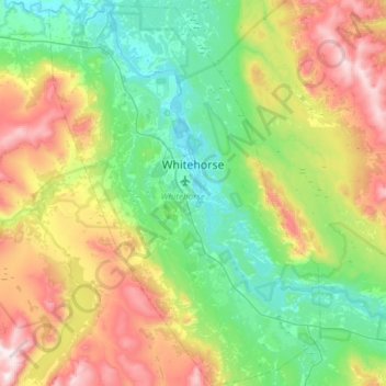
Name: Whitehorse topographic map, elevation, terrain.
Location: Whitehorse, Yukon, Canada (60.55364 -135.27872 60.84619 -134.85673)
Average elevation: 1,007 m
Minimum elevation: 629 m
Maximum elevation: 1,857 m
Whitehorse has a subarctic climate (Köppen climate classification: Dfc) and lies in the rain shadow of the Coast Mountains, causing precipitation totals to be quite low year-round. Due to the city's location in the Whitehorse valley, the climate is milder than other comparable northern communities such as Yellowknife, however during cold snaps it isn't uncommon for temperatures to drop below −40 °C (−40 °F). With an average annual temperature of −0.1 °C (31.8 °F) Whitehorse is the warmest place in the Yukon. The temperature measurements for the city are taken at the airport. The Whitehorse Riverdale weather station situated at a lower elevation than the airport is even warmer at 0.2 °C (32.4 °F).
Other topographic maps
Click on a map to view its topography, its elevation and its terrain.
Porter Creek
Canada > Yukon > Whitehorse
Porter Creek, Whitehorse, Yukon, Canada
Average elevation: 710 m
Burwash Landing
Canada > Yukon > Burwash Landing
Burwash Landing, Yukon, Y1A 3V4, Canada
Average elevation: 828 m
Destruction Bay
Canada > Yukon > Destruction Bay
Destruction Bay, Yukon, Y0B 1H0, Canada
Average elevation: 893 m
Beringia
Canada > Yukon > Yukon Crossing
Beringia, Klondike Highway, Yukon Crossing, Yukon, Unorganized, Yukon, Canada
Average elevation: 645 m
Mount Hubbard
Mount Hubbard, Yukon, Unorganized, Yukon, Canada
Average elevation: 3,866 m
Mount Vancouver
Mount Vancouver, Yukon, Unorganized, Yukon, Canada
Average elevation: 3,951 m
Mount Alverstone
Mount Alverstone, Yukon, Unorganized, Yukon, Canada
Average elevation: 3,701 m
Whitehorse, Unorganized
Whitehorse, Unorganized, Yukon, Canada
Average elevation: 1,126 m
Beloud Post
Canada > Yukon > Beloud Post
Beloud Post, Yukon, Unorganized, Yukon, Canada
Average elevation: 742 m
Mount Lucania
Mount Lucania, Yukon, Unorganized, Yukon, Canada
Average elevation: 4,657 m
Swift River
Canada > Yukon > Swift River
Swift River, Yukon, Unorganized, Yukon, Canada
Average elevation: 1,086 m