
Make a donation
Kirkwood topographic map
Click on the map to display elevation.
Make a donation
About this map
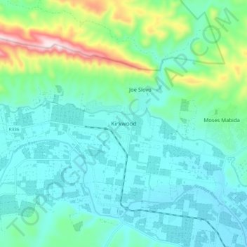
Name: Kirkwood topographic map, elevation, terrain.
Average elevation: 181 m
Minimum elevation: 76 m
Maximum elevation: 593 m
Make a donation
Other topographic maps
Click on a map to view its topography, its elevation and its terrain.
Sundays River
South Africa > Eastern Cape > Sarah Baartman District Municipality > Sundays River Valley Local Municipality
Average elevation: 27 m
Witrivier
South Africa > Eastern Cape > Sarah Baartman District Municipality > Sundays River Valley Local Municipality
Average elevation: 337 m
Make a donation
Map Position 36
South Africa > Eastern Cape > Sarah Baartman District Municipality > Sundays River Valley Local Municipality > Matyholweni Camp
Average elevation: 57 m
Rooidam
South Africa > Eastern Cape > Sarah Baartman District Municipality > Sundays River Valley Local Municipality
Average elevation: 174 m
Witrivier
South Africa > Eastern Cape > Sarah Baartman District Municipality > Sundays River Valley Local Municipality
Average elevation: 73 m