
Thank you for supporting this site ❤️
Make a donation
Make a donation
Hiroshima topographic map
Click on the map to display elevation.
Thank you for supporting this site ❤️
Make a donation
Make a donation
About this map
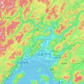
Name: Hiroshima topographic map, elevation, terrain.
Location: Hiroshima, Hiroshima Prefecture, Japan (34.28880 132.17855 34.61477 132.69610)
Average elevation: 300 m
Minimum elevation: -3 m
Maximum elevation: 1,127 m
Thank you for supporting this site ❤️
Make a donation
Make a donation
Other topographic maps
Click on a map to view its topography, its elevation and its terrain.