
Thank you for supporting this site ❤️
Make a donation
Make a donation
Krugersdrift topographic map
Click on the map to display elevation.
Thank you for supporting this site ❤️
Make a donation
Make a donation
About this map
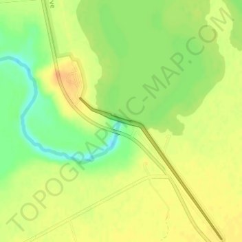
Name: Krugersdrift topographic map, elevation, terrain.
Average elevation: 1,248 m
Minimum elevation: 1,227 m
Maximum elevation: 1,261 m
Thank you for supporting this site ❤️
Make a donation
Make a donation
Other topographic maps
Click on a map to view its topography, its elevation and its terrain.
Thaba Nchu 1
South Africa > Free State > Mangaung Metropolitan Municipality
Average elevation: 1,527 m
Mangaung Ward 38
South Africa > Free State > Mangaung Metropolitan Municipality
Average elevation: 1,523 m
Mangaung Ward 47
South Africa > Free State > Mangaung Metropolitan Municipality
Average elevation: 1,378 m
Thank you for supporting this site ❤️
Make a donation
Make a donation
Martindale Kleinplase
South Africa > Free State > Mangaung Metropolitan Municipality
Average elevation: 1,381 m
Naval Hill Park
South Africa > Free State > Mangaung Metropolitan Municipality > Bloemfontein
Average elevation: 1,437 m
Thank you for supporting this site ❤️
Make a donation
Make a donation