
Hukunstsi Sub-district topographic map
Interactive map
Click on the map to display elevation.
About this map
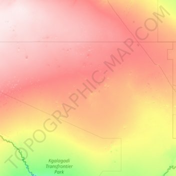
Name: Hukunstsi Sub-district topographic map, elevation, terrain.
Location: Hukunstsi Sub-district, Kgalagadi District, Botswana (-24.79513 19.99876 -23.31852 23.05919)
Average elevation: 1,120 m
Minimum elevation: 963 m
Maximum elevation: 1,300 m
Other topographic maps
Click on a map to view its topography, its elevation and its terrain.
Kgalagadi Transfrontier Park
Kgalagadi Transfrontier Park, Kgalagadi District, Botswana
Average elevation: 1,021 m
Bokspits
Botswana > Kgalagadi District > Bokspits
Bokspits, Kgalagadi District, Botswana
Average elevation: 860 m