
Vinhós topographic map
Interactive map
Click on the map to display elevation.
About this map
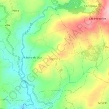
Name: Vinhós topographic map, elevation, terrain.
Location: Vinhós, Fafe, Braga, Portugal (41.47411 -8.18678 41.49432 -8.16170)
Average elevation: 353 m
Minimum elevation: 262 m
Maximum elevation: 482 m
Other topographic maps
Click on a map to view its topography, its elevation and its terrain.
Santa Comba
Portugal > Braga > Fafe > Fornelos
Santa Comba, Fornelos, Fafe, Braga, 4820-412, Portugal
Average elevation: 338 m