
Thank you for supporting this site ❤️
Make a donation
Make a donation
Likasi topographic map
Click on the map to display elevation.
Thank you for supporting this site ❤️
Make a donation
Make a donation
About this map
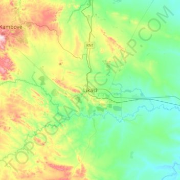
Name: Likasi topographic map, elevation, terrain.
Location: Likasi, Haut-Katanga, Democratic Republic of the Congo (-11.14916 26.57974 -10.82916 26.89974)
Average elevation: 1,270 m
Minimum elevation: 1,132 m
Maximum elevation: 1,603 m
Thank you for supporting this site ❤️
Make a donation
Make a donation
Other topographic maps
Click on a map to view its topography, its elevation and its terrain.
Kamina
Democratic Republic of the Congo > Haut-Katanga > Ville de Lubumbashi > N'sele
Average elevation: 1,207 m
Bel-Air 1
Democratic Republic of the Congo > Haut-Katanga > Ville de Lubumbashi
Average elevation: 1,258 m
Mohamed
Democratic Republic of the Congo > Haut-Katanga > Ville de Lubumbashi > Lubumbashi
Average elevation: 1,288 m
Thank you for supporting this site ❤️
Make a donation
Make a donation
Météo
Democratic Republic of the Congo > Haut-Katanga > Ville de Lubumbashi > Météo
Average elevation: 1,251 m