
Make a donation
Denver topographic map
Click on the map to display elevation.
Make a donation
Denver
Denver's downtown district lies about 12 miles (19 kilometers) east of the foothills of the Rocky Mountains. Named after James W. Denver, the governor of the Kansas Territory at the time, Denver was founded at the confluence of Cherry Creek and the South Platte River in 1858 during the Gold Rush era. Nicknamed the "Mile High City" because its official elevation is exactly one mile (5280 feet or 1609.344 meters) above sea level, Denver grew beyond its prospecting origins to become the principal commercial and transportation hub for a broad region spanning the Great Plains and Rocky Mountain West. The 105th meridian west of Greenwich, the longitudinal reference for the Mountain Time Zone, passes directly through Denver Union Station.
Make a donation
About this map
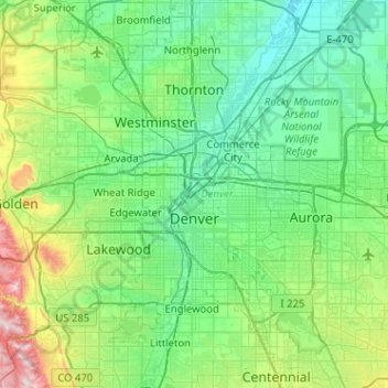
Name: Denver topographic map, elevation, terrain.
Location: Denver, Colorado, United States (39.61430 -105.10988 39.91421 -104.59970)
Average elevation: 1,684 m
Minimum elevation: 1,515 m
Maximum elevation: 2,397 m
Make a donation
Other topographic maps
Click on a map to view its topography, its elevation and its terrain.
Evergreen
United States > Colorado > Jefferson County
Evergreen sits at an elevation of 7,220 feet (2,200 m) in the Rocky Mountains, 19 miles west of Denver, Colorado. Its addresses are oriented according to the Street_system_of_Denver.
Average elevation: 2,309 m
Grand Lake
United States > Colorado > Grand County
Established in 1881, Grand Lake sits at an elevation of 8,369 feet (2,551 m) and derives its name from the lake on whose shores it is situated: Grand Lake, the largest natural body of water in Colorado. The town of Grand Lake was originally an outfitting and supply point for the mining settlements of Lulu…
Average elevation: 2,630 m
Make a donation
Mountain Village
United States > Colorado > San Miguel County
Mountain Village is a home rule municipality in San Miguel County, southwestern Colorado. It is located just southwest of Telluride, Colorado in the San Juan Mountains. The elevation of the town rises above Telluride to 9,600 feet. The population was 1,264 at the 2020 census.
Average elevation: 2,917 m
Make a donation
Estes Park
United States > Colorado > Larimer County
Estes Park sits at an elevation of 7,522 feet (2,293 m) on the front range of the Rocky Mountains at the eastern entrance of the Rocky Mountain National Park. Its north, south and east extremities border the Roosevelt National Forest. Lumpy Ridge lies immediately north of Estes Park.
Average elevation: 2,420 m
Buena Vista
United States > Colorado > Chaffee County
Buena Vista is located in central Colorado roughly midway between Salida and Leadville in the Upper Arkansas River Valley at an elevation of 7,965 feet (2,428 m). The area between Buena Vista and Salida is often referred to as the Denver & Rio Grande, South Park & Pacific, and Colorado Midland railroads. Many…
Average elevation: 2,457 m
Make a donation
Make a donation
Grand Mesa
United States > Colorado > Mesa County
The Grand Mesa is a large mesa in western Colorado in the United States. It is the largest flat-topped mountain in the world. It has an area of about 500 square miles (1,300 km2) and stretches for about 40 miles (60 km) east of Grand Junction between the Colorado River and the Gunnison River, its tributary to…
Average elevation: 2,666 m
Make a donation
Estes Park
United States > Colorado > Larimer County
Estes Park sits at an elevation of 7,522 feet (2,293 m) on the front range of the Rocky Mountains at the eastern entrance of the Rocky Mountain National Park. Its location is 40°22′22″N 105°31′09″W / 40.372856°N 105.519136°W / 40.372856; -105.519136. Its north, south and east extremities…
Average elevation: 2,543 m
Make a donation
Rico
United States > Colorado > Dolores County
Rico experiences an alpine subarctic climate (Köppen climate classification Dfc) with long, cold, very snowy winters and short, cool summers due to the high altitude and high precipitation year-round due to orographic lift.
Average elevation: 2,861 m
Make a donation
Make a donation
Make a donation
Pikes Peak
United States > Colorado > El Paso County
Pikes Peak or America's Mountain is an ultra-prominent fourteener of the Front Range of the Rocky Mountains of North America. Pikes Peak's summit has an elevation of 14,115 ft (4,302 m) above sea level. Pikes Peak is in Pike National Forest, Colorado, with the base located in the town of Manitou Springs, 10…
Average elevation: 3,902 m
Make a donation
Mount Elbert
United States > Colorado > Lake County
Mount Elbert is composed largely of quartzite. However, the summit ridge consists of metamorphic basement rock, which is Pre-Cambrian in origin and about 1.7 billion years old. There are various igneous intrusions including pegmatite, as well as bands of gneiss and schist. Unlike mountains of similar altitude…
Average elevation: 3,959 m
Make a donation
Longs Peak
United States > Colorado > Boulder County
Together with nearby Mount Meeker, with an elevation of 13,911 feet, the two mountains are sometimes referred to as the Twin Peaks (not to be confused with a nearby lower mountain called Twin Sisters).
Average elevation: 3,825 m
Crystal
United States > Colorado > Gunnison County
The elevation of Crystal is centered at 8,950 ft (2,728 m), however the area in and around crystal ranges from 8,500 ft (2,590.8 m) to peaks of 13,500 ft (4,114.8 m). The land is well drained, and the rock types, such as limestone, create very steep slopes, common in the Rocky Mountains. The area is described…
Average elevation: 3,146 m
Stanley Heights Subdivision
United States > Colorado > Larimer County > Estes Park
Average elevation: 2,345 m
Make a donation
Tabernash
United States > Colorado > Grand County > Tabernash
On August 10, 1984, a Cessna L-19 Bird Dog (registration N4584A), piloted by James Jeb Caddell, 36, crashed in a forest near Tabernash. The aircraft was en route from Granby to Jeffco Airport, Colorado. Despite the efforts of a search party, the two men could not be located, as the plane had flipped over and…
Average elevation: 2,593 m
Make a donation
Fairplay
United States > Colorado > Park County
The historic Town of Fairplay is the Statutory Town that is the county seat and the most populous municipality of Park County, Colorado, United States. The town population was 724 at the 2020 United States Census. Fairplay is located in South Park at an elevation of 9,953 feet (3,034 m). The town is the…
Average elevation: 3,045 m
Make a donation
Sleepy Cat Peak
United States > Colorado > Rio Blanco County
Sleepy Cat Peak, elevation 10,853 ft (3,308 m), is a summit in the Flat Tops of northwest Colorado. The mountain is east of Meeker in the White River National Forest of Rio Blanco County.
Average elevation: 3,090 m
Make a donation
Make a donation
Ouray
United States > Colorado > Ouray County
Ouray (/ˈjʊəreɪ/ YOOR-ay) is a home rule municipality that is the county seat of Ouray County, Colorado, United States. The city population was 898 as of the 2020 census. The Ouray Post Office has the ZIP Code 81427. Located at an elevation of 7,792 feet (2,375 m), Ouray's climate, natural alpine…
Average elevation: 2,717 m
Make a donation
Bennett
United States > Colorado > Adams County
Bennett is located at coordinates 39°45′32″N 104°25′39″W / 39.7589°N 104.4275°W / 39.7589; -104.4275 at an elevation of 5486 at the intersection of State Highways 36 and 79, just north of Interstate 70.
Average elevation: 1,692 m
Make a donation
Make a donation
Black Forest
United States > Colorado > El Paso County
The Black Forest CDP has an area of 64,447 acres (260.807 km2), including 37 acres (0.150 km2) of water. A possible highpoint for the Black Forest area is Vollmer Hill at 7704 feet (2348.2 meters) feet based on a traditional USGS Topographic map.
Average elevation: 2,208 m
Make a donation
Make a donation
Make a donation
Make a donation
Make a donation
Argentine Pass
United States > Colorado > Summit County
Argentine Pass, elevation 13,207 ft (4,025 m), is a high mountain pass that crosses the Continental Divide in the Front Range of the Rocky Mountains of central Colorado in the United States. Argentine Pass is located on the crest of the Front Range along the boundary southwest of Georgetown and is the highest…
Average elevation: 3,797 m
Rogers Pass
United States > Colorado > Gilpin County
Rogers Pass, elevation 11,866 ft (3,617 m), is a mountain pass in the Front Range of central Colorado. The pass crosses the continental divide in the James Peak Wilderness.
Average elevation: 3,448 m
Make a donation