
Hectorspruit topographic map
Interactive map
Click on the map to display elevation.
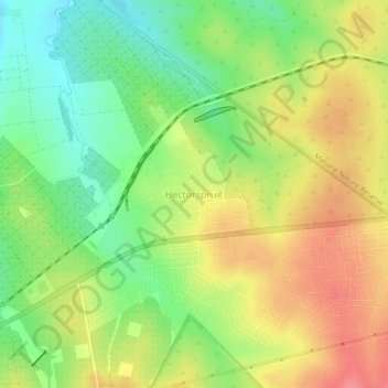
Hectorspruit topographic map, elevation, terrain
About this map
Name: Hectorspruit topographic map, elevation, terrain.
Average elevation: 274 m
Minimum elevation: 237 m
Maximum elevation: 311 m
Other topographic maps
Click on a map to view its topography, its elevation and its terrain.
Marloth Park
South Africa > Mpumalanga > Ehlanzeni District Municipality > Nkomazi
Average elevation: 220 m
Crocodile Bridge Rest Camp
South Africa > Mpumalanga > Ehlanzeni District Municipality > Nkomazi
Average elevation: 179 m
Lower Sabie Rest Camp
South Africa > Mpumalanga > Ehlanzeni District Municipality > Nkomazi
Average elevation: 181 m
Komatipoort
South Africa > Mpumalanga > Ehlanzeni District Municipality > Nkomazi
Average elevation: 173 m
Malalane
South Africa > Mpumalanga > Ehlanzeni District Municipality > Nkomazi
Average elevation: 352 m
Driekoppies Dam
South Africa > Mpumalanga > Ehlanzeni District Municipality > Nkomazi
Average elevation: 322 m